CONVECTIVE FORECAST
VALID Mon 30 May 06:00 - Tue 31 May 06:00 2005 (UTC)
ISSUED: 29 May 22:22 (UTC)
FORECASTER: GROENEMEIJER
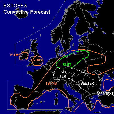
There is a slight risk of severe thunderstorms forecast across northern and northeastern Germany, northern Poland, southern Estonia, Russia Kaliningrad and northwestern Belarus.
SYNOPSIS
Monday at 06 UTC... an intense mid/upper trough over the British Isles moves eastward and reaches a line from Copenhagen to Prague 06 UTC Tuesday morning. Downstream of the trough a warm air-mass is present.
DISCUSSION
...northern Germany, northern Poland...
At 18Z a frontal zone was analyzed from near Luxembourg to near Dresden and further eastward over northern Poland. Around 1000 J/kg MLCAPE50 is available south of the front and a few 100's of J/kg elevated CAPE above the frontal zone as evidenced by 12Z and 18Z soundings.
Evolution of storms after 06 UTC will strongly depend on the evolution of the convective storms that have formed over northern France and Luxemburg around 22 UTC. The storms may form one or two forward-moving MCS's that move into northern Germany.
Current thinking is that the convection will indeed be over northern Germany around 06 UTC and move eastnortheastward into northern Poland. The system(s) may be weakening around that time. Redevelopment of the convection is expected over northern Poland during the early afternoon as the boundary layer warms and around 1000 J/kg surface-based CAPE should be able to form. The convection will likely re-organize into one or more linear MCS's that may cause some damaging winds while some large hail may occur as well.
...northern Switzerland, southern Germany, southern Poland, Czech Republic, Austria...
In response to pressure rises over France, the frontal zone is expected to accelerate southeastward as a cold front. Scattered storms are expected to initiate ahead of and in the frontal zone over central and southern Germany and northern Switzerland during the late morning or early afternoon. Storms will have a low threat of large hail and strong winds. The wind threat may increase if cells manage to organise into a larger convective system that moves into northern Austria and the Czech Republic. However, overall threat seems somewhat marginal, so that we refrain from issuing a risk category for the region at the moment.
...eastern and central Balkans, mid-Danube Plains, parts of northern Turkey...
Vertical shear will be moderate at best in the mentioned areas. Nevertheless, SBCAPE will likely rise to over 1000 J/kg and a few isolated severe weather events, including large hail and strong winds may occur with the scattered storms that are expected to form in the area.
#