CONVECTIVE FORECAST
VALID 06Z FRI 27/05 - 06Z SAT 28/05 2005
ISSUED: 26/05 17:40Z
FORECASTER: TUSCHY
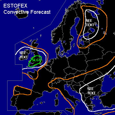
There is a slight risk of severe thunderstorms forecast across Great Britain
General thunderstorms are forecast across South east Europe
General thunderstorms are forecast across East Finland,Estonia,Latvia and extreme west Russia
SYNOPSIS
Strongly modified remains of ex-hurricane " Adrian" have crossed the Atlantic ocean, now arriving in NW Europe as a strong extratropical depression. Downstream of this system, very warm air in all levels will spread northeastward over most parts of western, central and even north eastern Europe. Downstream of this major ridging, broad upper level trough will be stationary during the forecast period over south east Europe and at the same time, a strong low pressure will push a cold front southeastward over Lapland and Finland.
DISCUSSION
...Great Britain ...
Strong depression will move northeastward during the next 24 hours, producing a broad warm front sector over France and south-central Great Britain...Most of the 12Z model runs have disposed of the convective precipitation signals over North France and Holland. Strong model variations with the strength of the depression - strength and expansion of WAA - make it difficult to pinpoint an area,where initiation will occur, but actual thinking is that isolated to scattered TSTMs should develop over central Great Britain in the afternoon hours along the leading edge of Theta-E tongue and the slowly northward moving warm front....Impressive deep layer shear of 40 to 55kt and up to 25kt low level shear will be more than adequate for rotating storms with the threat for strong to severe wind gusts and isolated large hail....In addition, very low LCLs and locally enhanced shear along the front will pose a risk for one or two tornadoes....Next round for initiation will be a cold front,which arrives in the early evening hours from southwest and isolated to scattered TSTMs can be expected to develop....main threat looks like to be strong to severe wind gusts....Finally,models show quite impressive convective signals over parts of Ireland in an environment with strong shear and lift....Current thinking is that area won't see much insolation because of thick cloud cover of cloud head and strong frontogenesis....Strong lift and low-end CAPE values could help to initiate some cells over Ireland with the main risk being strong to severe wind gusts and isolated lager hail,when colder mid level airmass arrives, but allover threat seems to marginal at the moment for upgrading....Front also drifts over the extreme western parts of Europe and combined with height falls and slightly cooler mid level airmass, isolated TSTM development can be expected....
...South east Europe...
Again...broad upper trough should disequilibrate the atmosphere enough for widespread TSTM development especially in the SEE TEXT area.Main threat will be marginal hail and isolated strong wind gusts during the mature phase of each storm. Bad kinematic parameters will preclude any organisation.
...East Finland,Estonia,Latvia and extreme west Russia...
Strong depression over east Norway and north Finland should continue to intensify and will push a cold front southeastward over the area of interest. Although instability parameters don't look very impressive on real time and forecast soundings, current thinking is that isolated to scattered TSTMs will develop along the cold front. Mostly shallow instability and impressive deep layer shear of more than 60kt maybe enough that many cells will struggle in forming an organized updraft....However,each TSTM will have the possibility for producing strong to severe wind gusts and marginal hail.
#