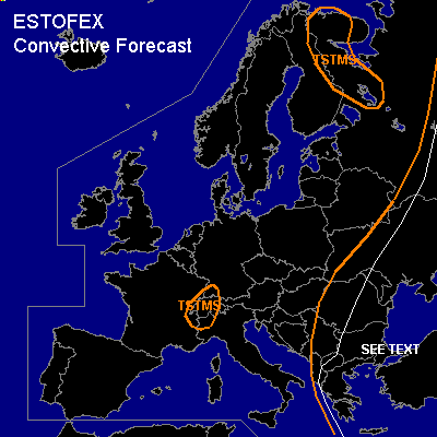

CONVECTIVE FORECAST
VALID 07Z THU 26/05 - 06Z FRI 27/05 2005
ISSUED: 26/05 07:26Z
FORECASTER: GATZEN
General thunderstorms are forecast across southeastern and eastern Europe
General thunderstorms are forecast across eastern Scandinavia
General thunderstorms are forecast across western Alpine region
SYNOPSIS
Subtropical upper high ridges northeastward over Europe ... with an axis extending from Morocco to Alpine region and Belarus. To the west ... deep southwesterly flow is present at the eastern flank of Atlantic long-wave trough ... and several short-wave troughs migrate northeastward over northwestern Europe, and Scandinavia. Another trough is present over southeastern Europe that is expected to dig slowly northeastward into Turkey during the forecast period. At lower levels ... convectively mixed airmass is present in the range of the southeastern trough. To the north ... well developed elevated mixed layer is present over extremely eastern Europe. Over western Europe ... WAA is present in the range of the ridge axis.
DISCUSSION
...Eastern Mediterranean, Greece, Aegean, southwestern Turkey
...
Convectively mixed airmass ... characterized by neutral to slightly unstable lapse rates and rather rich low-level moisture ... will likely destabilize during the day due to diurnal heating ... and thunderstorms are expected. Weak QG forcing and weak vertical wind shear should limit severe potential. However ... rather steep low-level lapse rates ... weak CIN and low LCL heights may enhance the chance for tornadoes locally ... especially where old outflow-boundaries/ orographic features will enhance low-level helicity. Allover threat should be too low for a SLGT.
...Black Sea region, Ukraine, and western Russia
...
From central Turkey to western Russia ... well developed elevated mixed layer is present ... yielding to CAPE in the order of 1000+ J/kg locally and 500+ J/kg over a rather broad region. Best chances for thunderstorms are expected just east of the forecast region ... where low-level frontal boundary/upper trough axis is expected. Although quite high CAPE may realize locally ... weak QG forcing and relatively weak deep layer wind shear should limit severe potential ... and will not issue a categorical risk. An isolated severe event or two are not ruled out, though.
#