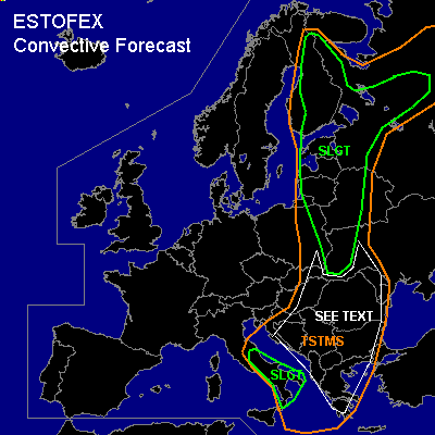

CONVECTIVE FORECAST
VALID 06Z TUE 24/05 - 06Z WED 25/05 2005
ISSUED: 24/05 01:22Z
FORECASTER: VAN DER VELDE
There is a slight risk of severe thunderstorms forecast across the Baltic States, Finland, Belarus and NW Russia
There is a slight risk of severe thunderstorms forecast across southern Italy
General thunderstorms are forecast across Italy, Balkan, eastern Europe and Baltic states, Finland
SYNOPSIS
A large shallow low pressure area over Eastern Europe is situated southeast of an upper trough over Scandinavia, and deeply unstable air is present in the airmass ahead of the frontal zone, that is being pushed eastward faster today. The most rapidly this will happen over the Baltic States SLGT area, with also the strongest lift along the front.
An upper cut-off low has moved to southern Italy.
DISCUSSION
...the Baltic States, Finland, Belarus and NW Russia...
GFS develops a slight wave in the frontal zone over the Baltics, moving NNE-ward, and a consistent additional moist air advection ahead of the cold front. GFS MLCAPE values seem fairly reasonable, expect values reaching 700-1500 J/kg. Due to the strong linear forcing and tightening pressure gradients in the trough, this may well be a squall line, possibly one continuing from the past night. As indicated by GFS and NMM, there is a prefrontal convergence line that may carry most of the convective activity, if so, the western parts of the SLGT will see lower chances of severe weather because it is expected to have passed the Baltics by 09Z (NMM). Another convergence line comes in from the east.
With moderate DL+LL shear, expect to see a large MCS that may affect southern Finland and NWrn Russia, mostly, with primary threat of severe gusts (notice also delta-theta-e >15) Other storms could form as well and strong multicells may well drop large hail and locally strong gusts. Some of these storms may become supercells and a tornado or two would not be ruled out.
Farther south, more isolated storms may form with main chance of large hail.
...mid-northern Finland...
Warm airmass is advected from the south. A strong shear and SREH area passes over northern Finland. As a few hundred J/kg MLCAPE are expected in the area plus strong forcing, supercell storms may develop with a threat of hail and a few tornadoes.
...southern Italy...
With GFS/NMM indicating 1000 J/kg MLCAPE... and 00Z Pratica di Mare having also 1038 J/kg and 40-50 kts winds around 400 hPa, a few hailstorms (large hail/amounts) may form in the (at least) moderate shear area near the upper low.
...Balkan...
Between Italy and Ern Europe SLGT, less geostrophic forcing mechanisms will be present, and the flow (and shear) is weaker... with CAPEs of about 500-1500 J/kg, fairly unorganised storms are expected to form which could drop large hail locally... in mountainous areas (which would also function as trigger, besides present convergence lines), large amounts of hail and rain could fall from slow-moving storms.
#