CONVECTIVE FORECAST - UPDATE
VALID 21Z FRI 20/05 - 06Z SAT 21/05 2005
ISSUED: 20/05 20:45Z
FORECASTER: TUSCHY / GROENEMEIJER
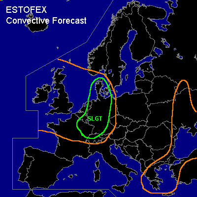
There is a slight risk of severe thunderstorms forecast across eastern France, eastern Benelux and western parts of Germany
General thunderstorms are forecast across parts of northwestern Europe and the Black Sea region.
SYNOPSIS
refer to synoptic forecast
DISCUSSION
...slight risk area...
Convection has failed to initiate near the frontal zone over western France, but instead substantially more convection than anticipated has initiated further to the east over east-central France within a lobe of high theta-e/theta-w over the area. In fact a cell with an echo-pattern with supercell characteristics has been ongoing over eastern France as well as two starting bow echoes.
Isolated convective storms are initiating over parts of the Benelux and northwestern Germany as well, as seen on radar imagery.
Convective development seems to occur in an area of warm advection in the warm sector of a baroclinic wave over the central Benelux at 21 Z. Backed surface winds especially over eastern France indicate that considerable storm-relative helicity... on the order of 200-300 m2/s2 may be available to storms there. As a result supercells are to be expected, that will pose a threat of hail, strong to severe winds and possibly a few tornadoes.
Present thinking is that additional cells will develop
in the southern and central parts of the slight risk area. Cells will intitially have an opportunity to become tornadic supercells, but gradually more activity will likely transform into strongly-forced bow-echoes capable of producing damaging winds over the risk area.
#