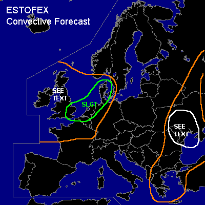

CONVECTIVE FORECAST
VALID 06Z FRI 20/05 - 06Z SAT 21/05 2005
ISSUED: 19/05 22:13Z
FORECASTER: TUSCHY
There is a slight risk of severe thunderstorms forecast across North Belgium,Holland, extreme north west Germany, Denmark and eastern England
General thunderstorms are forecast across Great Britain and Ireland
General thunderstorms are forecast across Moldova,Ukraina and White Russia
SYNOPSIS
Higly amplified pattern will continue during the forecast period. Major, near neutral stacked upper level low west of Ireland will shift slowly eastward. Strong jet will come out of the base of the system and should affect parts of north west Europe....Another, but weaker upper level trough over south east Europe will also move slowly eastward. Both systems and accompanying strong baroclinic zones will be the focus for TSTM development. South and central Europe will see rising pressure and strong WAA between both troughs and developing cap should inhibit cell development.
DISCUSSION
...North Belgium,Holland, extreme north west Germany, Denmark and eastern England...
Cold front will cross Great Britain during the first part of the forecast period from south west to north east. Although the front will move pretty parallel with the steering flow and should be not as active in south east Great Britain as further north, lift along the front should be enough for producing scattered TSTMs....enhanced lift by left exit region of upper and mid level jet and a tongue of nearly 500J/kg instability prefrontal should help for cell development....strengthening deep layer shear (~25m/s) and unidirectional flow would pose a risk for a developing line of storms with the main threat for some severe wind gusts and a marginal hail threat if discrete cell development occurs in front of this line...MCS should move east-northeastward and exit the SLGT region pretty fast....weakening because of decreasing instability and forcing should lower the severe weather risk.
Next feature of interest should be a short wave in the early evening hours, which should enter northern France in the noon hours. Main insecurity will be the instability along the baroclinic zone - NW France to Holland -....models don't develop a lot of instability over northern France and the bullseye of instability further south seems to be unrealistic , because models ( especially GFS) have too high dew points.Yesterday reports over north west France showed up to 13°C and I see no reason why this should change significantly. This, at least, more humid airmass could be advected eastward along the baroclinic zone....Forcing of this short wave and
additional convergence along the baroclinic zone should help to initiate isolated to scattered TSTM development from north west to north France. At the moment, models don't show a lot of convective signals over extreme north France but if more humidity will be advected eastward than anticipated at the moment, a westward expansion of the SLGT risk area has to be considered....Ingridients for more widespread TSTM development seem to come together over Holland, where strong forcing, some instability and convergence along the baroclinic zone should help for cell initiation... Early in the initiation stage and especially along the baroclinic zone, strong low level shear up to 25kt and low LCLs should pose a risk for some rotating storms with an isolated tornado risk,stronger hail and severe wind gusts. Later in the period, strengthening deep layer shear and clustering of the storms should change the convective mode into a linear mode with the main threat for severe wind gusts....the MCS should race northeastward towards Denmark in front of a potent mid and upper level jet.
...Great Britain and Ireland...
First round of TSTM development is expected with the cold front, mentioned above....Main risk will be an isolated wind gusts and marginal hail ( steeper lapse rates due to cold air mass aloft)...Not much subsindence forcasted in the wake of the front so expect widespread TSTM development during the rest of the forecast period with isolated strong wind gusts possible.
...Moldova,Ukraina and White Russia...
Downstream of broad and weakening trough over SE Europe, strong southerly flow developed over the past days and advected warm and very dry air over parts of Turkey....
Modification of airmass over the Black sea is the reason for a pretty broad area of instability, especially along a north-south orientated frontal zone over east Europe....
Greece should see scattered TSTM development under the cold mid and upper level airmass, which will destabilisize the atmopshere....Weak kinematic parameters won't favor any organisation of cells...Short wave, crossing the Black Sea during the noon and early afternoon hours should reach the SEE TEXT area in the evening hours.Widespread TSTM development is anticipated and main threat will be marginal hail and strong to isolated severe wind gusts....Past runs of GFS showed a backing wind area over the SEE TEXT area...combined with low LCLs there could be the possibility for one or two tornadoes, but insecurity of the development of the closed depression will keep me from upgrading...
Further north, along the baroclininc frontal zone, expect TSTM development...this development should occur under an increasingly diffluent flow , thus weakening wind field is anticipated.
#