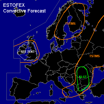

CONVECTIVE FORECAST
VALID 09Z THU 19/05 - 06Z FRI 20/05 2005
ISSUED: 19/05 09:47Z
FORECASTER: GATZEN
There is a slight risk of severe thunderstorms forecast across western central Romania and Bulgaria, northern Greece, Macendonia, eastern Serbia
General thunderstorms are forecast across Ukraine, southwestern Russia and Belarus, western Black Sea region to southern Italy
General thunderstorms are forecast across Scandinavia
General thunderstorms are forecast across Great Britain
SYNOPSIS
Well developed upper trough centered over northern Balkans digs southeastward reaching northern Greece at the end of the period. At its eastern flank, strong upper jet streak/vort max spreads northward affecting Greece, western Black Sea region, and western Ukraine on Thursday. At the surface ... a low pressure system has formed over Aegean Sea that is expected to remain during the day. To the north of this surface low ... a frontal boundary from western Ukraine to eastern Hungary, Serbia, central Greece should remain quasistationary until early afternoon. It divides cold polar airmass over central Europe from relatively warm airmass over Balkans. Over western Europe ... upper ridge is forming, yielding a southwesterly jet over northwestern Europe.
DISCUSSION
...Northern Greece, Macedonia, western Bulgaria, western Romania
...
Relatively cool airmass/convective outflow has spread southeastward into western Romania and Bulgaria during the night. To the east ... rather warm and quite moist low-level airmass is present from northern Greece to Romania, and Bulgaria. Latest Luij-Napoca sounding indicates rather steep lapse rates between 850 and 750 hPa ... and daytime heating should lead to instability as expected by latest model output. Initiation is expected during the early afternoon over western Bulgaria, extremely northern Greece, Macedonia, and western central Romania ... where low-level convergence is forecast in the range of the warm front. QG forcing due to DCVA should support this convection during the afternoon. Strong deep layer wind shear in the range of the jet axis ... reaching more than 25 m/s over Bulgaria ... should be sufficient for organized convection. Multicells and supercells may form ... capable of producing isolated large hail and severe wind gusts. The chance for tornadoes is also enhanced, especially along the warm front reaching from western Bulgaria into central Romania ... where low-level moisture and convergence should be most favorable. Over eastern Romania and Bulgaria ... latest soundings show strong capping inversion that should inhibit convection. Convective activity should cluster and weaken during the night.
...Great Britain
...
WAA is expected in the range of southwesterly flow regime over northwestern Europe. Associated airmass is slightly unstable as indicated by latest model output ... and CAPE is forecast during the afternoon/evening hours. Although sounding data is not available to characterize this airmass ... current thinking is that sufficient instability will form and capping inversion will be weak enough for scattered showers and thunderstorms. In the range of the WAA regime ... models suggest quite strong low-level vertical wind shear ... and a few convective cells may become mesocyclones. Given quite strong low-level wind shear and locally low LCL heights ... the chance of tornadoes should be enhanced. Isolated large hail and severe wind gusts are not ruled out. Overall threat seems to be too low for a SLGT.
#