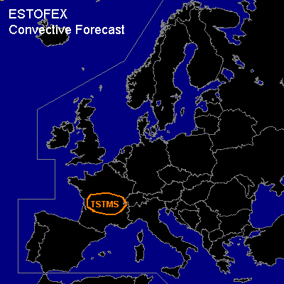

CONVECTIVE FORECAST
VALID 06Z FRI 18/03 - 06Z SAT 19/03 2005
ISSUED: 18/03 10:43Z
FORECASTER: GATZEN
General thunderstorms are forecast across central France
SYNOPSIS
Well developed high over western Europe ridges NNW-ward as intense arctic trough digs SE-ward over eastern Europe. At lower levels ... very cold airmass spreads into eastern Europe, while relatively warm airmass remains over the western and southern portions. Over Mediterranean ... very dry and stable airmass is present.
DISCUSSION
...France...
On Friday ... CAPE is expected to form over central France, where quite steep lapse rates are present. Latest observations show dewpoints up to 12°C over western central France. A capping inversion should limit thunderstorm potential. However ... strong insolation during the day should be sufficient to break the inversion locally ... especially where orographic features induce mesoscale forcing. Thunderstorms that form should be weak due to the lack of shear/forcing.
...Northern Black Sea region...
Over northern Black Sea region ... upper short-wave trough migrates eastward at the southern edge of eastern European long-wave trough. Latest soundings show low-level moisture north of the Black Sea, and quite steep lapse rates aloft ... and some CAPE is expected during the next hours. Along the trough axis ... some forcing may be possible ... and it is not ruled out that thunderstorms will form. However ... stratiform clouds seem to inhibit insolation ... and amount of CAPE forecast by latest GFS model run seems to be questionable ... and we desist from a thunderstorm forecast.
#