CONVECTIVE FORECAST
VALID 06Z TUE 15/03 - 06Z WED 16/03 2005
ISSUED: 15/03 01:26Z
FORECASTER: VAN DER VELDE
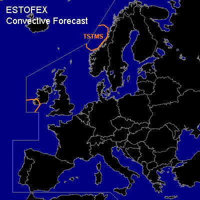
General thunderstorms are forecast across the Norwegian west coast
SYNOPSIS
A stationary Atlantic low causes warm air mass to overspread Europe in a southwestern flow. This causes a buildup of high pressure over southern Europe that will deflect cyclonic disturbances from Ireland and Great Britain to Scandinavia. The sharply defined warm front is forecast to have reached over Scotland and Denmark back into Poland and Austria by the end of the period.
Stable (and stabilizing) conditions will prevail over much of Europe, with the exception of the coastal zone of Norway where sparse lightning activity can be expected in convection at a disturbance in cold arctic maritime airmass.
At a tongue of high theta-e (WBPT >12C) associated with an occlusion accompanied by strong UVMs, some (elevated) somewhat thunderous activity may approach Ireland by the end of the period. No/weak CAPE signals were present in GFS 12Z/NMM, but there is some convective precip. Although forecast vertical shear and SREH values are strong, convection is most likely somewhat elevated and not able to consume the shear to produce severe weather.
DISCUSSION
#