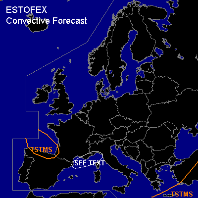

CONVECTIVE FORECAST
VALID 06Z THU 03/03 - 06Z FRI 04/03 2005
ISSUED: 02/03 19:12Z
FORECASTER: GATZEN
General thunderstorms are forecast across southeastern Mediterranean
General thunderstorms are forecast across southwestern Europe
SYNOPSIS
Broad upper trough is present over Europe ... and strong westerly jet is located over the Mediterranean. As rather intense upper trough moves southward over western Europe reaching the Iberian Peninsula on Thursday, upper flow turns to WSW over the Mediterranean. Over the southeastern portions ... upper trough moves eastward.
DISCUSSION
...Southeastern Mediterranean
...
Latest ascends show some instability in the range of upper trough over southeastern Mediterranean, where isolated thunderstorms have formed on Wednesday. Affected airmass is characterized by low-level steep lapse rates underneath a well-defined inversion at the 700 hPa level. Another inversion is present atop of the boundary layer, leading to CIN in the order of 200 J/kg. On Thursday ... warm air advection is expected especially in the mid troposphere, and instability should decrease during the day. A few showers and thunderstorms may form in the morning hours. Weak vertical wind shear and weak forcing is expected ... and severe thunderstorms seem to be not likely.
...Southwestern Europe
...
Rather strong upper trough moves southward into southwestern Europe. Along its periphery ... two well developed upper jet streaks are expected over western Mediterranean as well as from Iceland to Biscayan Bay. Both jet streaks should lead to rather strong QG forcing on Thursday. Over western Mediterranean ... rather steep low-level lapse rates are present as indicated by latest ascends. However ... poor low-level moisture seems to inhibit deep convection, and chances for thunderstorms should be low. Rather favorable vertical wind shear is expected in the eastern sector of developing surface low pressure system over France ... and chance for severe thunderstorms is significantly increased if thunderstorms will form. Allover threat seems to be quite low ATTM. To the northwest ... upper vort-max should reach northern Spain on Thursday. Affected cold airmass should be characterized by neutral lapse rates over the rather warm Atlantic sea surface. Showers and thunderstorms are forecast along the upper vort-max especially over northern Spain, where orographic lift is expected. Deep vertical wind shear seems to be unfavorable for severe convection.
#