
CONVECTIVE FORECAST
VALID 06Z SAT 26/02 - 06Z SUN 27/02 2005
ISSUED: 26/02 02:08Z
FORECASTER: VAN DER VELDE
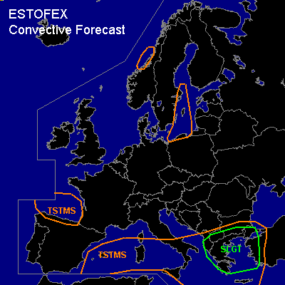
There is a slight risk of severe thunderstorms forecast across the southern Balkan and western Turkey
General thunderstorms are forecast across the Mediterranean Sea
General thunderstorms are forecast across the Gulf of Biscay and northern Spain
General thunderstorms are forecast across the Baltic Sea
SYNOPSIS
Large blocking high pressure area is present over the northern Atlantic, while most of Europe is under an upper low. Surface low pressure areas linger over the Gulf of Biscay, moving towards the western Mediterranean Sea, and a larger low is deepening towards the Balkan as warm theta-e air advects into the area. A waving frontal zone affects the Mediterranean, and the jetstream is displaced somewhat to the north of the theta-e gradient.
DISCUSSION
...Southern Balkan, western Greece...
GFS 12Z has indicated strong upward velocities associated with two waves in the frontal zone and shortwave upper troughs that would easily function as destabiliser. Model CAPE and convective precip signals suggest again likelyhood of thunderstorms. Farther south the instability will be increasingly elevated, according to GFS with LFCs over 3000m, but with some exceptions. The source area (Libya) is not sampled by soundings, but sat loops do show deep convection rapidly being advected towards the area.
Both NMM and GFS models initially forecast high SREH values (>250 m2/s2) in the theta-e plume, but when convection will be elevated, not much of this will be effective for storm rotation. Deep layer shear will be somewhat less than previous days, but low-level shear is progged to be significant (>10m/s 0-1 km), also over northern parts of the area where convection may be more surface based, from advection over sea. The combination of strong low-level shear over Turkey, enhanced deep CAPE and a 850 hPa wind field over 20 m/s pose a threat of one or more tornadoes, marginally large hail and especially severe convective gusts.
The second wave, associated with the passage of the cold front, is passing Greece late in the forecast period and is forecast to be accompanied by more deep layer shear, but especially by strong 0-1 km shear (>15 m/s) over Greece. Severe gusts and one or two tornadoes are likely, especially if a squall line manages to develop.
...Gulf of Biscay area / Baltic Sea...
see the SEE TEXT discussions of the previous day. Biscay comma cloud may enhance the chance of a few waterspouts due to linear convergence zone.
#