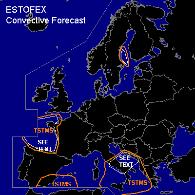

CONVECTIVE FORECAST
VALID 06Z FRI 25/02 - 06Z SAT 26/02 2005
ISSUED: 25/02 01:01Z
FORECASTER: VAN DER VELDE
General thunderstorms are forecast across The Gulf of Biscay
General thunderstorms are forecast across SErn Spain/Mediterranean
General thunderstorms are forecast across Srn Italy and west coasts of the Balkan
SYNOPSIS
Yesterdays low over NWrn France will drift southward into the Gulf of Biscay. Frontal waves are forecast to affect SEern Spain and Srn Italy/Balkan, with clear low-level convergence and 700 hPa UVV signatures in the GFS and NMM models. By the end of the forecast period, a ridge of relatively high theta-e air approaches Greece from the SSW.
DISCUSSION
...Gulf of Biscay area...
Convection has been in the form of open-cells, and little change is expected for today. The Best Thu 12Z sounding showed fairly steep lapse rates, benign vertical shear and enhanced low level humidity. Together with the cold pool synoptic setup this is rather typical for occurrence of a few waterspouts. However, a good wind shift line is generally required, which has not formed the day before. As convection is expected to deepen as indicated by NMM CAPE/LI fields, thunder becomes increasingly likely.
...Srn Italy / Wrn Balkan...
Marginal instability along a baroclinic zone is expected to keep producing local thunderstorms. Convective precip and 700 hPa UVVs from GFS/NMM are forecast and indicate strong lifting conditions. Nothing much seems to have changed from the day before. SREH values are progged to reach up to 200 m2/s2 locally, and also deep layer shear and low-level shear indicate possibility for brief rotation in storm updrafts. An isolated tornado could be the result.
...Botnic Gulf...
Whilst an arctic cold front descends over the area late in the forecast period, instability is likely to develop over due to the temperature contrast of the Botnic Gulf and the overrunning cold airmass. Sparse lightning could be possible, since cloud tops, albeit not high, reach over the -20C level. The GFS model is projecting a thermal circulation convergence zone over the Gulf, that might organise convection easily into a line. Along this cloud line spouts may be possible.
#