CONVECTIVE FORECAST
VALID 06Z THU 24/02 - 06Z FRI 25/02 2005
ISSUED: 23/02 23:24Z
FORECASTER: VAN DER VELDE
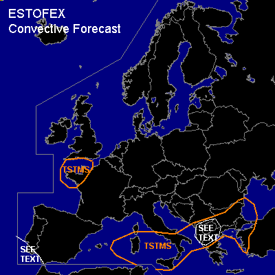
General thunderstorms are forecast across southern Italy, portions of the Balkan and western Turkey
General thunderstorms are forecast across extreme western France
SYNOPSIS
A large scale low pressure system is present over western and central Europe both at surface and upper level flow pattern. Two cores swirl around in the main low. The first one, of Mediterranean origin is filling up and moving northward, while the second one is a westward moving wave in an occlusion that also advected out of the Mediterranean a few days earlier, heading for northwestern France. A jetstream is present along the edge of warm and cold air masses over southern Europe.
DISCUSSION
...Albania area...
Only weak instability is displayed by GFS and NMM models, but synoptic upward velocities and some convective precip forecast by GFS between 06Z and 12Z could indicate some potential of reasonably deep convection over this area. Given the strong deep layer shear, and fairly strong low level shear possibly aided by local orography, potential could exist for briefly rotating updrafts with a chance of an isolated tornado, but overall the situation looks rather marginal.
...coastal SW Spain/Portugal...
Attention should be paid to rather strong low-level instability in GFS 12Z and some convective precip that could indicate convection in conditions supportive of a few waterspouts.
...coastal areas of western France...
By the end of the forecast period, GFS and NMM forecast negative LI's over the area with a chance of thunderstorms near the core of the upper low. Given the superadiabatic lapse rates created by the cold air over relatively warm sea water, the typical low shear environment and enhanced low level buoyancy, the situation may induce formation of a waterspout or two, especially if line convection would form.
#