CONVECTIVE FORECAST
VALID 06Z MON 21/02 - 06Z TUE 22/02 2005
ISSUED: 20/02 23:27Z
FORECASTER: GROENEMEIJER
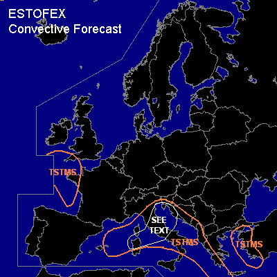
General thunderstorms are forecast across parts of western France and the extreme southwestern UK, parts of the western Mediterranean Sea, Italy, the Adriatic and its coasts, the Ionean Sea and across the eastern Aegean Sea and western Turkey.
SYNOPSIS
Mondat at 06 GMT, a mid-upper low is forecast over northern Italy. A cold air-mass is advected southwestward along its northwestern flanks. As it overspreads the English Channel and warm Atlantic waters some deep convection capable of producing some lightning may result.
A west-east oriented frontal zone is forecast over the western Mediterranean. Some CAPE may develop in the the polar air mass on the side of the jet affecting northern parts of the western Mediterranean and near the low centre over the northern Adriatic. Warm advection and upward vertical motions inducing destabilisation are expected to affect the central/southern the Adriatic and the eastern Ionean Sea. Thunderstorms are likely to affect these areas as well. Scattered storms will additionally be possible across the eastern Aegean Sea and western Turkey.
DISCUSSION
...Central Italy and the northern Adriatic...
The approach of a shortwave trough will likely induce rising motions affecting central Italy in the late morning and early afternoon and the northern Adriatic thereafter. If some storms develop near this disturbance, these may be associated with strong gusts in the rather strongly sheared environment.
#