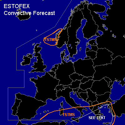

CONVECTIVE FORECAST
VALID 06Z FRI 18/02 - 06Z SAT 19/02 2005
ISSUED: 17/02 19:00Z
FORECASTER: GATZEN
General thunderstorms are forecast across southern central and eastern Mediterranean
General thunderstorms are forecast across northern North Sea to southwestern Scandinavia
SYNOPSIS
Expanded upper long-wave trough present over Mediterranean digging slowly eastward. Another polar trough propagates southeastward annexing to the European trough as Atlantic high ridges northward into Greenland. At lower levels ... cold airmass will remain in the range of the European trough and spreading eastward over eastern Mediterranean. Over central and eastern Mediterranean ... cold airmass is characterized by neutral to unstable lapse rates due to convective mixing above the rather warm sea surface.
DISCUSSION
...Mediterranean
...
Another round of convective activity is expected over the Mediterranean, where convectively mixed airmass will remain in the range of the upper trough. Thunderstorms should form in this weak-capped airmass especially underneath the cyclonic flank of the jet that will be present northeast of a line from southern Mediterranean to Turkey. Furthermore ... a vort-max is expected to move from central Mediterranean eastwards ... affecting southern Italy, Greece, and the Aegean Sea, where widespread thunderstorms are forecast during the day. Organized thunderstorms seem to be unlikely over northern and central Mediterranean, where weak deep layer wind shear is present. To the south and east ... deep layer wind shear should increase significantly in the range of the upper jet ... enhancing the potential of severe thunderstorms. Bow echoes and mesocyclones may form, capable of producing severe wind gusts and isolated large hail. Allover threat is expected to be rather low, as amount of instability and QG forcing will be limited. Mesoclyclones that form might have a slightly enhanced tornadic potential given rather low LFC heights. Due to weak low-level wind shear, tornadoes are not expected ATTM, though.
...North Sea
...
Underneath the axis of propagating trough ... relatively warm maritime airmass will be present in the range of a cold front occlusion. Although instability should remain quite low, isolated thunderstorms are expected due to rather strong QG forcing. Thunderstorms that form may have the potential of producing strong wind gusts. Allover threat should be low.
#