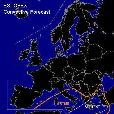

CONVECTIVE FORECAST
VALID 06Z THU 17/02 - 06Z FRI 18/02 2005
ISSUED: 16/02 18:13Z
FORECASTER: GATZEN
General thunderstorms are forecast across Mediterranean, western Black Sea region
SYNOPSIS
Between high geopotential over the northern Atlantic and western Asia ... an amplified upper trough is present over Europe centered over the central Mediterranean. This upper long-wave trough is forecast to be quasi-stationary during the forecast period. At lower levels ... cold airmass has spread over Europe including the Mediterranean. Over extremely southeastern Europe and eastern Mediterranean ... some WAA was present on Wednesday at the eastern flank of the upper trough and should remain east of a cold front that is expected to move eastwards on Thursday. Over northwestern Europe ... another long-wave trough starts to migrate southeastwards into central Europe.
DISCUSSION
...Mediterranean...
Cold airmass is present over the Mediterranean and should remain on Thursday west of a frontal boundary stretching from southern Mediterranean to Greece and further to western Black Sea. This airmass is characterized be quite steep lapse rates as indicated by numerous soundings. Over the western Mediterranean, airmass seems to be rather dry and capped, while instability is increasing to the east, where low level moisture is increasing and mid troposphere lapse rates are steeper ... yielding CAPE values in the order of 100 J/kg. This is also forecast by latest GFS model run for the central and eastern portions of the Mediterranean. Aloft ... synoptic forcing and upper troposphere winds should be weak in the center of the upper trough, where showers and thunderstorms will likely be non-severe. To the east ... rather strong upper jet is present at the southeastern flank of the trough ... and a jet streak is expected to move northeastwards over eastern Mediterranean on Thursday ... inducing DCVA at the cyclonic flank of the upper jet from southern Mediterranean to the Aegean Sea and further to western Black Sea region. As a consequence, thunderstorms are expected from central Mediterranean to the northern Aegean Sea. Strong deep layer wind shear exceeding 30 m/s is forecast and thunderstorms may organize into bowing lines and/or mesocyclones. Severe wind gusts and isolated large hail may be possible. Although low-level wind shear will be quite low, chance for tornadoes should be slightly enhanced given quite low LFC heights. Allover threat seems to be too low to warrant a categorical risk at this time, as QG forcing should remain relatively weak and instability will be limited. Further east ... cyclogenesis is forecast along the frontal boundary as the upper jet approaches. Rather warm airmass should spread northward east of the cold front that should reach a line from southern Mediterranean to eastern Aegean on Thursday, 12Z. Latest model output suggests only marginally instability in the warm sector of the developing frontal wave. However ... it is not completely ruled out that thunderstorms will form underneath the upper jet streak that may lead to sufficient QG forcing. If thunderstorms will form ... isolated severe storms are not ruled out as deep layer wind shear will be quite high.
#