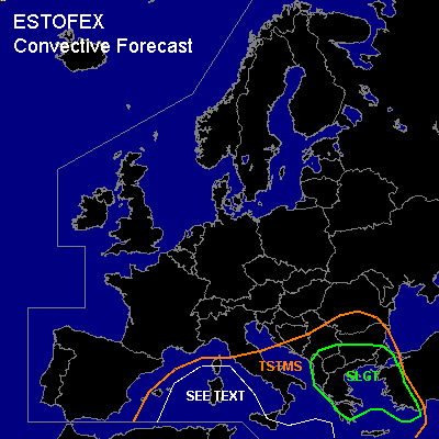

CONVECTIVE FORECAST
VALID 06Z TUE 15/02 - 06Z WED 16/02 2005
ISSUED: 15/02 01:23Z
FORECASTER: VAN DER VELDE
There is a slight risk of severe thunderstorms forecast across the southern Balkan and western Turkey
General thunderstorms are forecast across much of the Mediterranean Sea
SYNOPSIS
A blocked pattern with high pressure over the Atlantic Ocean to Scandinavia, and low pressure over southeastern Europe with its core near Albania. Cold air is being advected over the relatively warm Mediterranean Sea, creating instability and thunderstorms. A frontal wave associated with a negatively tilted upper shortwave trough is sweeping over the Srn Balkan and western Turkey.
DISCUSSION
...Aegean Sea coasts of Turkey and Greece (eastern part of SLGT)...
Pressure gradients on the east side of the low, near the cold front are strong Tue morning (60 kts 850 hPa) and in combination with convective momentum transport, a main risk of severe convective gusts (but also non-convective) will be present. The shortwave upper trough is progged to generate strong synoptic scale ascent. Previous days 12Z Greece soundings in the warm sector were already hinting at easy destabilisation, and there is little doubt that the strong forcing will generate widespread storms.
GFS fields indicate presence of low-level buoyancy and convective precip, while also the NMM model forecasts CAPE of a few hundred J/kg over sea areas, supporting the probability of convection.
Shear (>20 m/s 0-6 km, >10m/s 0-1 km, and SREH >200 m2/s2) is strong mainly over land areas, as opposed to instability, so coastal zones will likely see the greatest threat of severe weather. Besides damaging straightline winds, this may as well include a few tornadoes marginally large hail, as shear parameters are sufficient for storm updraft rotation and enhanced by local topography.
...Southwestern Balkan (western part of SLGT)...
Behind the cold front, cold unstable air is likely to lead to some convective development over land due to diurnal heating and forcing by upper shortwaves turning around the low. GFS 12Z shows some enhanced CAPE and convective precip. NMM is more conservative with CAPE over land, but LIs are near zero, not much excluding convective
development.
Since forecast shear values reach into >12m/s 0-1 km, >20m/s 0-6 km shear and possibly some SREH over 100 m2/s2 at postfrontal troughs/backbent occlusion, this may pose a threat of an isolated tornado / marginally large hail / severe gusts event.
...rest of TSTMS area...
Very steep low level lapse rates due to cold air advection over the warm Mediterranean Sea in shallow pressure gradients (benign vertical shear) look favorable for convection spawning a number of waterspouts throughout the area, especially when convection concentrates on lines of convergent near-surface winds to ingest vorticity.
#