
CONVECTIVE FORECAST
VALID 06Z MON 14/02 - 06Z TUE 15/02 2005
ISSUED: 14/02 00:31Z
FORECASTER: GROENEMEIJER
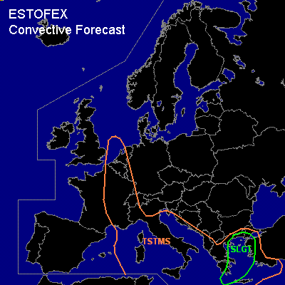
There is a slight risk of severe thunderstorms forecast across southern and eastern Greece, much of the Aegean Sea and northwestern Turkey.
General thunderstorms are forecast across parts of the southern North Sea, the Low Countries and across eastern France, the western Alps, much of south-central Europe, Greece, the Aegean Sea and western Turkey.
SYNOPSIS
Monday at 06 UTC, a longwave trough from Poland to southern Italy dominates the weather maps. Ahead of a vorticity maximum rotating around itys base pressure falls are expected to leqad to cyclogenesis over the southern Adriatic.
DISCUSSION
...Slight risk area...
Over the Aegean Sea a tightening gradient in combination with orographic effects is expected to lead to the formation of a 35-40 m/s southerly low-level jet. The jet is forecast to advect warm air rapidly northward that should become marginally unstable (a few 100 J/kgs SB-CAPE) per NMM/AFWA MM5. The warm air advection and subtle forcing for upward vertical motion will likely result in the development of scattered thunderstorms on Monday evening and overnight that may organize into linear convective systems. Earlier on Monday scattered storms can already be expected along coasts where the wind is forced to flow upslope.
The strong low-level gradient suggests that severe gusts will likely occur even in absence of deep convection after 00Z, and may become very strong with thunderstorms. Additionally, tornadoes will be possible. A minor threat of large hail will exist as well. An upgrade to moderate risk may be needed later on.
#