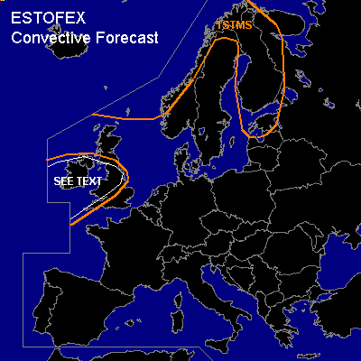

CONVECTIVE FORECAST
VALID 06Z FRI 11/02 - 06Z SAT 12/02 2005
ISSUED: 10/02 17:20Z
FORECASTER: GATZEN
General thunderstorms are forecast across northwestern Europe, northwestern British Isles
SYNOPSIS
Intense upper long-wave trough is present from Greenland to western Scandinavia to the north of well-developed upper high over the Atlantic. Strong upper jet is directed towards northern Europe between these two systems. Latest models agree that a intense cyclone will form underneath the upper jet that should affect western and central Europe on Saturday. Broad delta of upper jet is located over eastern Europe.
DISCUSSION
...Northwestern Europe
...
Isolated thunderstorms should be possible underneath the upper long-wave trough .. where neutral lapse rates are present as indicated by latest 01415 Stavanger ascend. A vort-max that is forecast to stretch from eastern Baltic Sea to northern Scandinavia ... and DCVA is expected to lead to QG forcing. Along the trough axis ... showers and isolated thunderstorms are forecast. However ... latest model output suggests very little CAPE ... limiting thunderstorm potential. Weak deep vertical wind shear in the range of the trough axis does not support organized convection. At the end of the period ... intense surface cold front should affect northwestern British Isles. Rather strong forcing should be possible along this cold front. Affected warm airmass should be quite moist, leading to low LCL heights and probably weak CAPE. If thunderstorms will form ... strong low-level vertical wind shear will be present ... enhancing the chance for tornadoes. An update may be necessary on Friday evening.
#