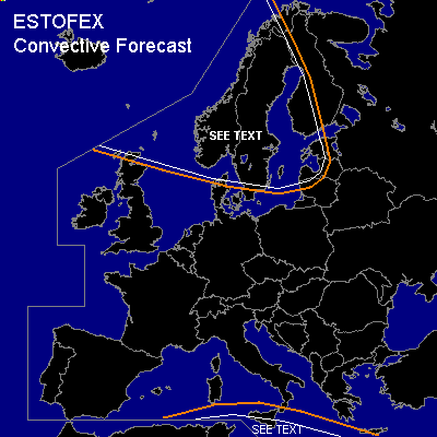

CONVECTIVE FORECAST
VALID 06Z THU 10/02 - 06Z FRI 11/02 2005
ISSUED: 09/02 13:37Z
FORECASTER: GATZEN
General thunderstorms are forecast across southern Mediterranean
General thunderstorms are forecast across Scandinavia
SYNOPSIS
Upper ridge is present from southwestern Europe to western Russia. To the south ... axis of sharp upper trough stretches from Maroc to Greece. To the north ... polar long-wave trough east of Greenland will propagate eastward, and well developed vort-max is expected to cross Scandinavia during the period.
DISCUSSION
...Southern Mediterranean
...
Quite unstable low-level airmass is present over southern Mediterranean ... with steep low level lapse rates and low LFC heights ... creating CAPE in the lowest 2 km. On Thursday ... models suggest that low-level moisture will decrease and CAPE should weaken. Aloft ... upper short-wave trough is expected to weaken while it moves eastward ... and upper forcing should be quite low. Current thinking is that convective activity should weaken on Thursday. Given low deep layer vertical wind shear and QG forcing ... chance for severe thunderstorms should decrease significantly. However ... as LFC heights will be quite low ... and 0-1 km low-level wind shear should be moderate on early Thursday ... chance of tornadoes will be slightly enhanced.
...Scandinavia...
Well developed upper trough axis will move eastward over Scandinavia. In the range of this trough ... neutral to slightly unstable airmass is expected ... and showers and thunderstorms are forecast along the trough axis. Relatively weak deep layer wind shear is expected in the range of the trough axis ... and organized convection is not likely. However ... given quite strong low-leel wind shear ... chance of tornadoes should be slighly enhanced. Allover threat seems to be quite low, though. Best chances for thunderstorms is expected along western Scandinavia ... where orographic lift may support deep convection.
#