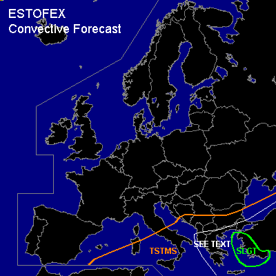

CONVECTIVE FORECAST
VALID 06Z FRI 28/01 - 06Z SAT 29/01 2005
ISSUED: 27/01 16:09Z
FORECASTER: GATZEN
There is a slight risk of severe thunderstorms forecast across western Turkey
General thunderstorms are forecast across southern Black Sea, Turkey, eastern Mediterranean, southern Balkans, southern central Mediterranean
SYNOPSIS
To the south of high geopotential from Iceland to northern Russia, well developed long-wave trough is present from eastern Europe to northwestern Africa. Cold and stable airmass dominates in the range of this trough. At the southeastern flank of this upper trough ... a combination of polar front jet and subtropical jet forms a very strong jet streak exceeding more than 80 m/s at the 200 hPa level. At lower levels ... a frontal boundary separates cold airmass in the range of the upper trough over northwestern Africa from warm and well-mixed airmass that is advected northward over northeastern Africa. At the northern nose of this WAA regime ... a warm front is forecast over northern Turkey.
DISCUSSION
...Eastern Mediterranean, western Turkey and Black Sea region
...
Southeast of intense long-wave trough over western Mediterranean and northwestern Africa ... very strong upper jet is directed from Africa to eastern Mediterranean and Black Sea region. Several embedded vort-maxima travel northeastward with the upper flow. At lower levels ... another plume of warm air is advected northward into eastern Mediterranean ... reaching the Black Sea on Friday. Latest soundings over northeastern Africa indicate rather steep lapse rates above the boundary layer, and temperature is expected to reach up to 10°C at the 850 hPa level over Turkey at the end of the forecast period. While this airmass is stable over Africa ... models suggest increasing low level moisture over eastern Mediterranean and southern Black Sea on Friday. Latest 17607 Athalassa (Cyprus) sounding almost shows mixing ratios of 7 g/kg underneath the inversion. On Friday ... several vort-maxima will travel northeastward over eastern Mediterranean and Turkey ... and QG UVM is forecast due to WAA and DCVA. Affected airmass should be stable/strongly capped over southeastern Mediterranean. To the north ... increasing low-level moisture and orographic lift along the Turkish coast may be sufficient to break the cap. Showers and thunderstorms are forecast over western Turkey, where strongest instability is expected. Strong deep-layer shear is forecast under the strong jet reaching more than 35 m/s at 500 hPa, and low-level wind profiles veer considerably with height with southeasterly surface winds over northeastern Mediterranean. If thunderstorms will occur, chance for mesocyclones will be enhanced as 0-3 km SRH values reach up to more than 400 m²/s² over western Turkey ... expect damaging wind gusts the main threat. Large hail and a tornado is not ruled out, though. To the north ... amount of instability should remain low over Black Sea region ... where stratiform rain is expected in the range of the warm front. At the end of the period ... embedded thunderstorms may form over southwestern Black Sea region. Severe convection is not completely ruled out due to strong vertical wind shear along the frontal boundary.
...Eastern central Mediterranean, Greece
...
At the western edge of eastern Mediterranean WAA regime ... cyclogenesis is forecast over central Italy. Associated cold front should propagate eastward reaching Greece at the end of the period. Although latest model output suggests only marginal instability ... strong forcing along the cold front should be sufficient to initiate showers and thunderstorms. Over Greece ... rather strong deep layer wind shear and veering profiles are expected ... and mesocyclones are not ruled out ... capable of producing severe wind gusts and probably a tornado. Overall threat seems to be low due to marginal instability.
#