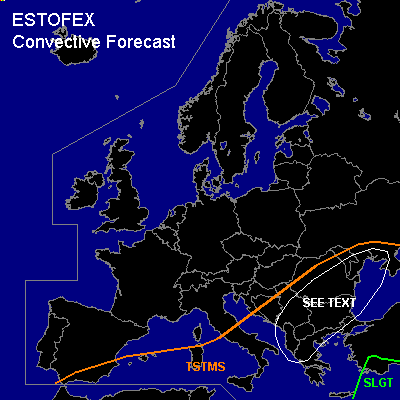

CONVECTIVE FORECAST
VALID 06Z THU 27/01 - 06Z FRI 28/01 2005
ISSUED: 26/01 18:00Z
FORECASTER: GATZEN
There is a slight risk of severe thunderstorms forecast across southwestern Turkey
General thunderstorms are forecast across southern and central Mediterranean, Black Sea region, southern Balkans
SYNOPSIS
East of very strong upper high south of Iceland ... an elongated upper long-wave trough is present over western Mediterranean. At its southern and southeastern flank ... strong upper jet streak is directed from northern Africa to western Black Sea. At the surface ... cold front of complex low pressure system over northern Mediterranean moves eastward into western Black Sea.
DISCUSSION
...Western Black Sea region, Turkey
...
Strong upper jet over eastern Mediterranean will remain during the forecast period ... and delta of strong upper flow is expected to move northeastward into northern Black Sea region. At the cyclonic flank of this upper jet ... strong DCVA is expected in the range of propagating vort-maxima. At lower levels ... a strong cyclone moves northward over Romania, western Ukraine, and Belarus. A cold front is expected to move into central Black Sea and western Turkey on Thursday. To the southeast ... airmass is characterized by relatively steep lapse rates as indicated by latest 17062 Istanbul sounding. Strong DCVA and some WAA is expected in the warm sector of the cyclone ... and thunderstorms are forecast along the cold front and should spread northward. Strong deep layer wind shear ... with more than 25 m/s 0-6 km wind shear ... will be sufficient for organized convection. While quite low instability over the Black Sea should limit potential for intense thunderstorms ... CAPE up to more than 300 J/kg is expected over western and southwestern Turkey ... where widespread thunderstorms are forecast. Current thinking is that a convective line with embedded thunderstorms will move eastward over Black Sea region and western Turkey ... and severe wind gusts should be the main threat. Over Turkey ... potential for mesocyclones will be greater ... capable of producing large hail and a tornado or two ... and a SLGT is warrant ATTM. To the west ... convective mixed airmass spreads eastward. DCVA is present and UVM should be strong enough to initiate showers and thunderstorms. Strong deep layer vertical wind shear will be present ... and LEWP and embedded mesocyclones are not ruled out. Severe wind gusts will be the main threat with these storms.
#