CONVECTIVE FORECAST - UPDATE
VALID 06Z WED 26/01 - 06Z WED 26/01 2005
ISSUED: 26/01 06:01Z
FORECASTER: GROENEMEIJER
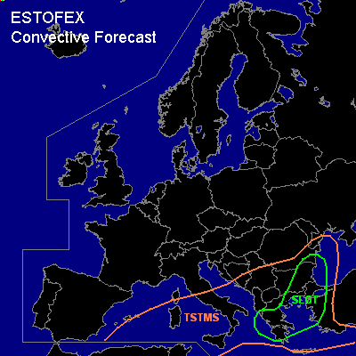
There is a slight risk of severe thunderstorms forecast across much of Greece, the Aegean Sea, western Turkey, central and eastern Bulgaria and southeastern Romania.
General thunderstorms are forecast across parts of the western Mediterranean Sea, the Tyrrhenean Sea, southern Italy, the Ionean Sea and the southern Adriatic Sea, the southern and eastern Balkans, Greece and parts of Turkey.
SYNOPSIS
Wednesday at 06 UTC...a blocked flow pattern is expected over Europe. A high pressure system at mid-tropospheric levels is located 500 km west of Ireland, and a low just south of the Cote d'Azur. Between the systems a strong northeasterly jet is forecast from the North Sea to northern Spain and another jet is expected south of the low from southern Tunesia to southern Greece.
DISCUSSION
...slight risk area...
A few 100s of J/kg MUCAPE are expected over the Ionean and Aegean seas near the axis of the jet. A trough located over Tunisia at 06Z is expected to move rapidly downstream and induce strong mesoscale rising motions over southern Greece in the late afternoon and early evening and move onward to affect the Aegean, northern Greece, Bulgaria and Romania during the evening and overnight.
Strong deep-layer shear is expected under a strong jet reaching 35 m/s at 500 hPa, and low-level wind profiles veer considerably with height, as was measured at Izmir, Thessloniki and Athens at 00Z, while exhibiting strong speed shear as well (~20 m/s in the 0-1 km layer).
Ahead of the aformentioned shortwave, rising motions are expected to incude the formation of storms near the Greek west coast. In the warm advection regime over the Aegean Sea and perhaps into the southeastern Balkans and into western Turkey, isolated to scattered storms are expected to form during the day before storm coverage increases during the evening as the shortwave affects the area.
Storms will likely cluster into several MCS's.
Vertical shear is more than adequate for storm rotation. Supercells and bows are expected posing a threat of severe gusts (i.e. in excess of 25 m/s) and a few tornadoes. Marginally severe hail is possible as well. The storms are expected to move into Bulgaria and later Romania and the western Black Sea region during the evening and overnight.
#