CONVECTIVE FORECAST
VALID 06Z TUE 25/01 - 06Z WED 26/01 2005
ISSUED: 25/01 00:04Z
FORECASTER: VAN DER VELDE
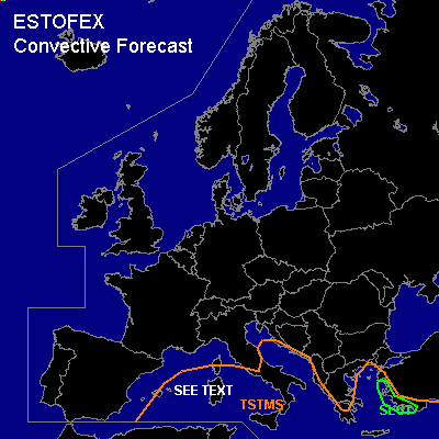
There is a slight risk of severe thunderstorms forecast across the southwest coast of Turkey
General thunderstorms are forecast across the Mediterranean Sea
SYNOPSIS
Between a strong high pressure area west of Scotland/Ireland and low pressure over Italy, cold air is being advected southward over much of Europe, and maximum temperatures will drop below freezing. Convection will be shallower than the previous day over western Europe. As deep cold air advects over the Mediterranean, instability will develop up to a few hundred J/kg CAPE in some places, having a depth of around 5 km, with wintery precipitation and thunder.
At the other side of the Mediterranean low, relatively warm air is advected ahead of the cold front into the southeastern Balkan and western Turkey.
DISCUSSION
...southwestern Turkey...
Deep instability up to 300-1000 J/kg in the warm sector indicated by GFS and NMM in combination with more than 20 m/s deep layer shear, >10 m/s 0-1 km shear and likely over 200 m2/s2 SREH with ample lift and model precip signals seem favorable for thunderstorms that may bear a threat of especially severe gusts, and possibly marginally large hail and one or two tornadoes, if storms develop rotation.
...Mediterranean Sea...
Especially the western Mediterranean Sea may see waterspouts in the low shear, high low-level lapse rate+buoyancy environment in lines of convergence.
#