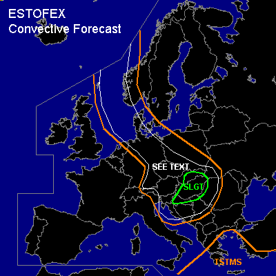

CONVECTIVE FORECAST
VALID 06Z FRI 21/01 - 06Z SAT 22/01 2005
ISSUED: 20/01 16:53Z
FORECASTER: GATZEN
There is a slight risk of severe thunderstorms forecast across northern Balkans, Hungary, eastern Czech Republic
General thunderstorms are forecast across eastern North Sea, northern and eastern Germany, Poland, southeastern Europe
General thunderstorms are forecast across eastern Mediterranean
SYNOPSIS
Center of intense upper long-wave trough placed over southern Scandinavia and moves eastward crossing the Baltic Sea on Friday. Associated surface pressure system is forecast to weaken over the Baltic Sea. The cold front of this surface low should reach from northern Mediterranean to western Black Sea to western Russia at the end of the period. To the south and west ... cold airmass is advected into central and eastern Europe.
DISCUSSION
...Southern central and southeastern Europe
...
At the southwestern flank of mentioned intense upper trough ... a strong jet streak (up to more than 70 m/s @ 300 hPa) is expected from northern British Isles to Alpine region and should reach southern Balkans during the day. Underneath the cyclonic flank of this upper jet ... a well developed cold front over northern Alpine region is expected to move rapidly southeastward reaching the Black Sea at the end of the period. To the south ... relatively warm and moist airmass is advected eastward into southeastern Europe. On Friday ... QG forcing underneath the left exit region of the upper jet is expected due to DCVA and WAA ... and maritime airmass should destabilize as indicated by model output. Some CAPE and LI in the range of 2 K may be possible. Along the cold front ... very strong UVM may be sufficient for convection ... and a narrow band of showers and thunderstorms is expected to form along the leading edge. Strong (15+ m/s 0-1km and 50+ m/s 0-6km) vertical wind shear is forecast by latest GFS model run in the range of the cold front ... and LEWP and embedded mesocyclones are expected ... capable of producing severe wind gusts, isolated large hail, and a tornado or two. Best chances for severe convection is forecast over eastern Austria, Czech Republic, Hungary, and northern Balkans, where upper forcing and instability should be maximized.
To the northwest ... deep mixed cold airmass is expected to destabilize in the range of several vort-maxima. Showers and thunderstorms are forecast. Strong vertical wind shear will be present ... and organized convection is not ruled out. If mesocyclones will form ... severe wind gusts will be the main threat. However ... isolated large hail and a tornado or two are not ruled out completely.
#