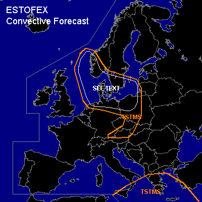

CONVECTIVE FORECAST
VALID 06Z THU 20/01 - 06Z FRI 21/01 2005
ISSUED: 19/01 18:43Z
FORECASTER: GATZEN
General thunderstorms are forecast across parts of central Europe, North Sea, Baltic Sea
General thunderstorms are forecast across eastern central Mediterranean
SYNOPSIS
Broad and strong ridge is present over SWrn Europe and northern Atlantic. To the east ... northwesterly upper current dominates Europe. An amplified upper short-wave trough present over central Mediterranean will propagate eastward, as intense upper trough moves SSE-ward into central Europe. At the surface ... intense cyclone will cross southern Scandinavia. The cold front occlusion will reach the Alps and eastern Europe at the end of the period.
DISCUSSION
...Central Europe
...
At the southwestern flank of long wave trough over northern Europe ... strong upper jet streak travels SEward into southern central Europe. At lower levels ... a cold front is expected to move southeastward over central Europe. In the range of this front ... relatively warm and moist airmass will be present. Current thinking is that shallow convection will form in the range of the front/trough. Isolated lightning is not ruled out completely ... however ... thunderstorms seem to be not very likely ATTM. Over North Sea and Baltic Sea region ... convectively mixed cold airmass should destabilize north of the exit region of the upper jet streak ... and showers and thunderstorms are forecast. Strong low level wind shear will be present ... and severe wind gusts are expected. As SRH values will be quite high ... it is not ruled out that some thunderstorms will organize ... with a chance of hail. A tornado is not ruled out as low LCL height will be present.
#