CONVECTIVE FORECAST
VALID 06Z TUE 18/01 - 06Z WED 19/01 2005
ISSUED: 17/01 23:56Z
FORECASTER: VAN DER VELDE
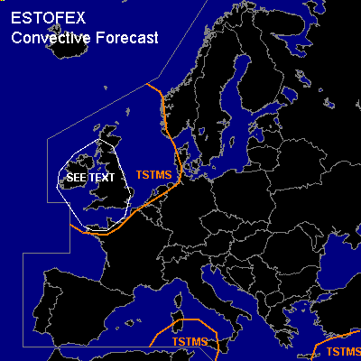
General thunderstorms are forecast across The Atlantic, Ireland and UK, North Sea
General thunderstorms are forecast across the eastern Mediterranean
General thunderstorms are forecast across the central/southern Mediterranean
SYNOPSIS
A longwave upper trough sinks down over Europe. Ahead of the unstable maritime polar airmass a cold front will be situated from Nrn Spain via Luxembourg to Denmark by Tue 06Z. At 18Z, cyclogenesis is forecast over Nrn Italy along the cold front under the left jet exit, and this will lead to an intensifying depression under a cut-off upper low affecting much of the central Mediterranean area. The northwestern jet over Ireland is forecast to reach over 150 kts at 300 hPa. More stable conditions are found south of the jet axis, under relatively high pressure.
DISCUSSION
...UK and Ireland, coast of NWrn France...
Deeply unstable airmass flows out over the region, on IR imagery this seems uniformly organised into clustered cells. A shortwave trough is however forecast to pass the region during the morning, which may enhance organisation of storms. As instability is driven by deep cold air flow over the warm gulf stream, the coastal zones will see most and strongest convective activity.
Low level shear and convergence are enhanced by friction over land areas and is forecast to amount over 15 m/s 0-1 km shear, while also deep layer shear is strong (>40 m/s 0-6 km)due to the jet and enhancement by the trough. SREH is progged to reach over 250 m2/s2, given the computed storm motion from the northwest.
The resulting threats are mainly severe gusts, possibly an isolated tornado - a candidate SLGT risk. Additionally, wintery precip can cause adverse traffic conditions.
#