
CONVECTIVE FORECAST
VALID 06Z THU 13/01 - 06Z FRI 14/01 2005
ISSUED: 12/01 17:25Z
FORECASTER: GATZEN
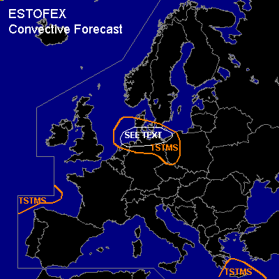
General thunderstorms are forecast across southern North Sea and Baltic Sea region, eastern Germany and western Poland
General thunderstorms are forecast across eastern Mediterranean
General thunderstorms are forecast across western Bay of Biscay
SYNOPSIS
In the wake of relatively intense upper trough over Scandinavia ... a vort-max ATTM over the British Isles is expected to travel southeastward into southern Baltic Sea region. While associated surface low pressure system over Scandinavia weakens ... upper high over southwestern Europe ridges northward into British Isles and Iceland. Over eastern Mediterranean ... a weak upper trough moves eastward.
DISCUSSION
...Southern North Sea and Baltic Sea region
...
Upper short-wave trough is expected to cross the southern North Sea and Baltic Sea region ... and QG forcing is expected in the range of the trough axis due to weak WAA and DCVA. Affected airmass ATTM over northern British Isles is convectively mixed as indicated by latest ascends and should lead to sufficient instability for showers and thunderstorms ... that should affect the southern North Sea and northern Benelux/Germany, and Denmark on Thursday morning. Convection should spread southeastward into southern Baltic Sea region, eastern Germany, and Poland during the day, where thunderstorms seem to be not very likely as CAA is expected and QG forcing should weaken. Due to strong surface pressure gradient ... low-level wind shear is expected to reach more than 10 m/s over Denmark, Benelux, and Germany ... and strong wind gusts are forecast in the range of showers and thunderstorms due to convective mixing. As low-level SRH will be enhanced as indicated by latest GFS model run ... isolated organized convection is not ruled out ... capable of producing isolated hail and severe wind gusts.
#