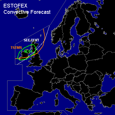

CONVECTIVE FORECAST
VALID 06Z TUE 11/01 - 06Z WED 12/01 2005
ISSUED: 11/01 01:27Z
FORECASTER: VAN DER VELDE
There is a slight risk of severe thunderstorms forecast across Ireland and northern UK
SYNOPSIS
An Atlantic depression in a southwestern upper flow deepens from 980 hPa at Tue 00Z to 948 hPa Wed 00Z (NMM/GFS). The accompanying wind field can produce damaging gusts, also away from convection (reason for SEE TEXT). After the cold front leaving Ireland around 15Z, unstable maritime polar air mass will allow convection, including thunderstorms.
DISCUSSION
...SLGT area...
Strong kinematic fields in presence of unstable airmass behind the cold front allow for severe damaging gusts enhanced by convective downdrafts, but given the strong wind field these will also occur outside convection.
GFS-indicated SREH values over land are over 100 m2/s2 and will even increase to over 300 m2/s2 during the night. The NMM model ranges even higher. Deep convection may acquire rotating updrafts, that may spawn a few tornadoes. 0-1 km shears are more than enough for this as well.
Deep layer shear is best under the jet, which resides more over southern portions of the SLGT area, whereas low level shear is best over northern parts. Convection is expected to be most vigorous at the western coasts in the area, where models indicate smallest LI's. Small to marginally large hail may develop out of these storms, additionally.
Storms are expected to be best organised ahead of two shortwave troughs that circle the low, passing the area during the evening and night, and may organise into bowing echo segments with the enhanced risk of severe gusts.
#