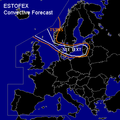

CONVECTIVE FORECAST
VALID 06Z SUN 09/01 - 06Z MON 10/01 2005
ISSUED: 08/01 21:19Z
FORECASTER: DAHL
General thunderstorms are forecast across the Nordic Sea ... the North Sea ... Denmark ... S Scandinavia ... the Baltic Sea ... the western Baltic States.
SYNOPSIS
Broad and strong upper WLY flow is stretching across Europe ... with vigorous embedded trough over S Scandinavia on Saturday evening swinging northeastwards into NW Russia by Monday 06Z. Upstream short-wave trough is progged to cross the North Sea and N-central Europe until early Sunday afternoon ... and dig into the N Ukraine by Monday 06Z. In the wake of this feature ... upper ridging will overspread central Europe ... with quiescent conditions persisting over the SRN parts of Europe.
DISCUSSION
...SEE TEXT area...
Postfrontal polar-air convection over the North Sea should undergo some strengthening as upper trough overspreads the North Sea during the first half of the period. Large-scale SFC winds will likely reach severe levels ... but convection may enhance the wind gusts locally. Also ... shallow mesocyclones may form in the reasonably stronly sheared environment ... producing marginally severe hail and maybe a brief tornado or two. Allover organized severe TSTM threat seems to be rather low however. Convection should spread across Denmark into the Baltic Sea ... and possibly into the Baltic States late on Sunday.
#