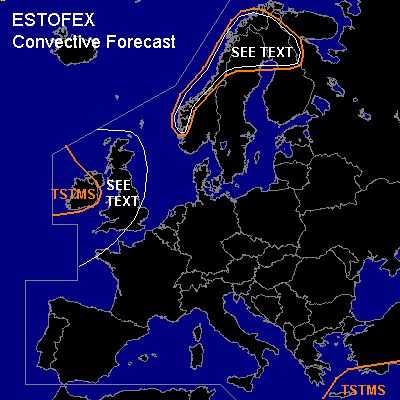

CONVECTIVE FORECAST
VALID 06Z FRI 07/01 - 06Z SAT 08/01 2005
ISSUED: 06/01 19:25Z
FORECASTER: GATZEN
General thunderstorms are forecast across northern and western Scandinavia
General thunderstorms are forecast across Ireland
General thunderstorms are forecast across eastern Mediterranean
SYNOPSIS
Very strong upper high is present over SW Europe ... and strong southwesterly jet expands northeastward from western Europe to central Scandinavia and further to northeastern Europe. Several vort-maxima that are embedded in the upper flow are forecast ... and latest GFS model run suggests rapide cyclogenesis over the British Isles at the end of the period. Over eastern Mediterranean ... a short-wave trough that crossed central Europe on Thursday cuts off. At lower levels ... warm maritime airmass spreads northeastward over central Europe ... reaching western Russia on Saturday.
DISCUSSION
...Scandinavia...
A positively tilted short-wave trough is expected to cross northern Scandinavia during the day. At lower levels ... relatively warm airmass is advected eastward as occluded frontal system of northwestern Scandinavian surface low propagates northeastward. GFS suggests some CAPE and QG UVM in the range of this occlusion. If thunderstorms will form during the afternoon and evening hours ... rather strong low-level wind shear ... and more than 100 m²/s² SRH in the lowest kilometer seem to support organized convection ... and a few rotating updrafts capable of producing isolated large (soft) hail, severe wind gusts and a tornado are not ruled out. Chance for thunderstorms seems to be quite low ATTM ... as amount of instability should be rather low. Along the western Scandinavian coast ... thunderstorms should form due to orographic UVM. Locally enhanced SRH values near the coast may be sufficient for rotating updrafts ... and one or two severe events are not ruled out.
...Ireland, Great Britain
...
Latest GFS model run expects rapide cyclogenesis during Friday/Saturday night over Great Britain. Fast moving cold front is forecast to reach the British Isles at the end of the forecast period. Although maritime warm sector airmass should be rather stable and severe convection is not forecast ... it is not completely ruled out that isolated convective cells may develop along the cold front ... where high SRH values may be sufficient for tornadoes. To the west ... convectively mixed polar airmass is expected ... and thunderstorms are forecast. Strong surface pressure gradient and strong upper flow should be sufficient for severe wind gusts ... but allover threat of organized convection seems to be too low for a SLGT as QG forcing should be weak due to CAA.
#