CONVECTIVE FORECAST
VALID 06Z WED 05/01 - 06Z THU 06/01 2005
ISSUED: 05/01 00:49Z
FORECASTER: GROENEMEIJER
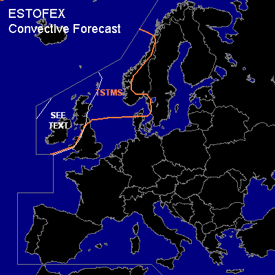
General thunderstorms are forecast across parts of the British Isles, western Norway, the northern North Sea and the Norwegian Sea
SYNOPSIS
Wednesday at 06Z...a broad zonal mid- and upper tropospheric flow is present over the northern Atlantic and western and central Europe. A weakly amplified and fast-moving trough is located northwest of the British Isles and is expected to reach a line from the central Norwegian Sea to southern Scandinavia to southern Germany on Thursday morning.
DISCUSSION
...British Isles...
In the lower troposphere, the aformentioned trough is chracterized by a depeening baroclinic depression initially located 500 km northwest of Ireland, moving northwestward and later northward. Strong 30-35 m/s winds at 850 hPa are expected south of the low within its warm sector. Some latent instability up to around 600 hPa is forecast by NMM within a zone of strong (~20 m/s) low-level shear and up to around 400 m2/s2 0-3 km SRH near the rather diffuse cold front of the depression. GFS seems not to contradict this and predicts strong upward motions there. Some linear convective elements will likely occur near the front, that could locally contain rotating updrafts producing severe wind gusts and perhaps a tornado or two as well. Chances of this happening will likely diminish as the front moves into eastern Scotland and England, where kinematics and instability should be less favourable for severe convection.
Overall threat with this type of low-instability situations is usually quite low and will therefore refrain from issuing a risk category.
#