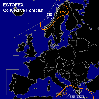

CONVECTIVE FORECAST
VALID 06Z THU 30/12 - 06Z FRI 31/12 2004
ISSUED: 29/12 21:01Z
FORECASTER: GATZEN
General thunderstorms are forecast across eastern central Mediterranean
General thunderstorms are forecast across western Scandinavia
SYNOPSIS
As strong upper jet streak moves eastward into central Europe ... upper long-wave ridge over southwestern Europe expands eastward into Alpine region and European trough cuts off into central Mediterranean. A strong jet streak is expected to travel along the edge of the building cut-off reaching eastern Mediterranean on Thursday. Over northern Europe ... well developed short-wave trough is forecast to cross western Scandinavia.
DISCUSSION
...Eastern central Mediterranean
...
Strong southwesterly upper jet streak will spread into eastern Mediterranean during the forecast period ... and deep vertical wind shear will increase as indicated by latest model runs. At lower levels ... low surface pressure will be present over central Mediterranean ... and southeasterly winds and WAA is expected east of southern Italy. Warm airmass is characterized by relatively steep low-level lapse rates and low-level CAPE in the order of a few hundred J/kg as indicated by latest ascends. On Thursday ... QG forcing is forecast in the range of the upper jet streak and showers and thunderstorms are expected. Strong deep layer wind shear will be present and rotating updrafts are expected. However ... low coverage of thunderstorms due to forecast weak QG forcing and CAPE is expected ... and overall threat seems to be too low to warrant a slight risk. A few severe gust, hail and tornado events are not ruled out though.
...Western Scandinavia
...
A strong upper short-wave trough is forecast to travel eastward over Scandinavia. Affected airmass will be convectively mixed over relatively warm sea surface. Showers and thunderstorms are forecast. Although QG forcing and deep layer wind shear seem to be too low for a well-developed comma cloud ... strong surface pressure gradient will be present ... and severe wind gusts will be likely. The threat of tornadoes should be enhanced due to locally high low-level SRH values in the range of the western Scandinavian coast.
#