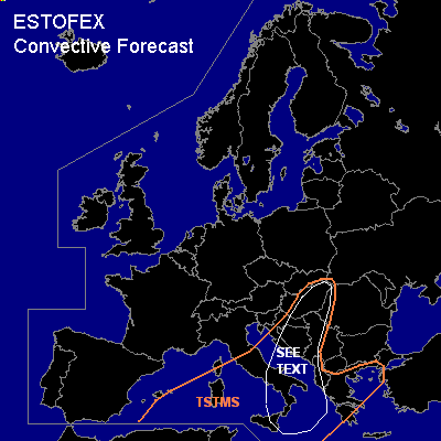

CONVECTIVE FORECAST
VALID 06Z MON 27/12 - 06Z TUE 28/12 2004
ISSUED: 27/12 09:01Z
FORECASTER: GROENEMEIJER
General thunderstorms are forecast across the Central Mediterranean, central and southern Italy, the Adriatic, the western Balkans and parts of Hungary an across Greece
SYNOPSIS
Monday at 06Z... at mid and upper-levels, an amplified trough was located over the western Mediterranean with a seperate low-pressure core over eastern Spain. A southwesterly jet was located from central Algeria over southern Italy into western Romania. A surface cyclone is located in the Gulf of Genua.
DISCUSSION
...See text area...
Marginal latent instability is analysed over parts of the entire western and central Mediterranean area, both on the poleward and equatorward side of the jet. Strong deep-layer and low-level shear should be more than sufficient to sustain rotating updrafts where thunderstorms form and a couple of (embedded) supercells may result. It is expected that instability may stretch well into the continent as ascending motion in the left exit region of the jet, so that a few thunderstorms may occur as far from the Mediterranean as eastern Hungary. Nevertheless, overall storm coverage will likely be rather low as well as the degree of instability. The overall chance of severe events, therefore seems not to require a categorical risk. The threat will be limited to a small tornado chance as well as a risk of small hail and severe gusts in the area indicated as "SEE TEXT".
#