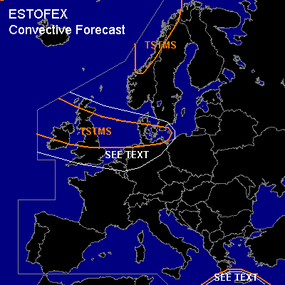

CONVECTIVE FORECAST
VALID 06Z THU 23/12 - 06Z FRI 24/12 2004
ISSUED: 22/12 15:07Z
FORECASTER: GATZEN
General thunderstorms are forecast across NW-ern Europe, SW-ern Baltic Sea
General thunderstorms are forecast across eastern Mediterranean
SYNOPSIS
At the southern edge of intense upper trough over northern Atlantic ... a strong upper jetstreak travels ESE-ward into western Central Europe. At lower levels ... relatively warm maritime airmass is advected eastward into Central Europe south of intense surface cyclones over Scandinavia. This airmass is characterized by a moist boundary layer yielding to poor low-level instability.
DISCUSSION
...Northwestern Europe and Baltic Sea region
...
Slightly unstable maritime airmass is advected eastward west of a propagating cold front. On Thursday ... a vort-max is expected to travel eastward over NW-ern Europe reaching the southern Baltic Sea on Friday morning. In the range of this vort-max ... QG forcing is expected ... and showers and thunderstorms are forecast. Strong vertical wind shear will be present from Great Britain to southern Baltic Sea ... and low-level SRH is expected to reach more than 100 m²/s² as indicated by lastest GFS model run. Although instability should be marginal ... a few shallow mesocyclones capable of producing tornadoes and severe wind gusts are not ruled out. Overall threat seems to be quite low.
...Eastern Mediterranean
...
In the range of eastward moving upper trough ... showers and thunderstorms are forecast. 20+ m/s deep layer wind shear will be present ... and it is not ruled out that organized convection will form ... capable of producing isolated large hail or severe wind gusts. Overall threat seems to be very low though.
#