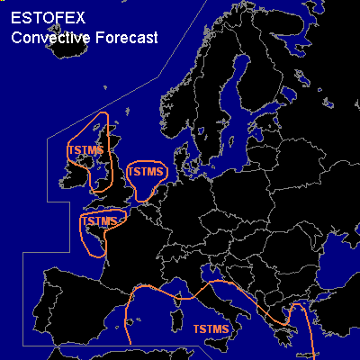

CONVECTIVE FORECAST
VALID 06Z MON 20/12 - 06Z TUE 21/12 2004
ISSUED: 20/12 02:41Z
FORECASTER: GROENEMEIJER
General thunderstorms are forecast across northern and western parts of the UK and the north of Ireland, the Irish Sea, the Channel and northern Bay of Biscay and across the southern north Sea as well as across the western Mediterranean Sea, southern Italy, the southern Adriatic Sea and parts of Greece and the Aegean Sea.
SYNOPSIS
Monday at 06 Z... the major features are two troughs embedded in a northwesterly flow. One is located over sea northwest of Ireland and another over southeastern France. The Irish trough is expected to move southeastward and reach the Channel on Tuesday morning. Ascent associated with differential advection of cyclonic vorticity ahead of the trough, is expected to destabilise the atmosphere sufficiently to create some latent instability suffient to sustain a couple of thundery wintry showers.
A similar story is valid for the French trough, although this trough is expected to move faster reaching Greece on Tuesday morning as the storms shift eastward in concert. Scattered storms are expected to develop over the western Mediterranean on Monday. The storms are generally not expected to be severe as both instability and shear are low. A few waterspouts may however occur.
DISCUSSION
#