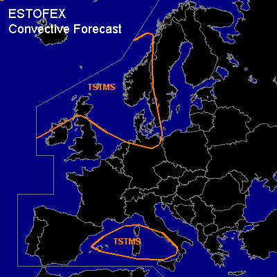

CONVECTIVE FORECAST
VALID 06Z THU 16/12 - 06Z FRI 17/12 2004
ISSUED: 15/12 14:41Z
FORECASTER: GATZEN
General thunderstorms are forecast across northern Great Britain, North Sea, western Scandinavia northern Germany, and western Baltic Sea
General thunderstorms are forecast across western Mediterranean
SYNOPSIS
To the east of strengthening long-wave ridge over the Atlantic ... a very strong NWrly jetstream will form over NWrn Europe ... and most of the continent will be covered by the extended delta of this upper jet on early Friday. At the cyclonic flank of the upper jet, several strong vort-maxima will affect NWrn Europe. Over the western Mediterranean ... a weak upper short-wave trough will move eastward.
DISCUSSION
...NWrn Europe
...
A strong vort-max is forecast to travel from Great Britain and northern North Sea to Scandinavia and western Baltic Sea during the forecast period. Along the trough axis ... convectively mixed airmass should destabilize due to DCVA and weak WAA ... and showers and thunderstorms are expected to occur over northern Great Britain, North Sea, western Scandinavia northern Germany, and western Baltic Sea. Relatively weak deep layer wind shear ... and rather poor instability seems to inhibit organized convection. However ... severe wind gusts will be possible due to high surface pressure gradient.
#