CONVECTIVE FORECAST
VALID 06Z WED 15/12 - 06Z THU 16/12 2004
ISSUED: 15/12 00:03Z
FORECASTER: GROENEMEIJER
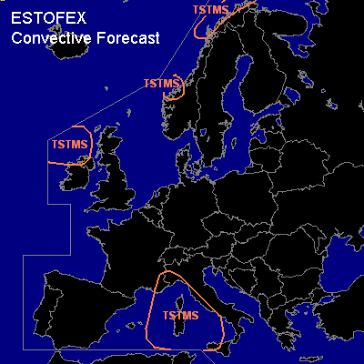
General thunderstorms are forecast across northern parts of Ireland and northern Ireland, parts of western and northern Norway and across southeastern France and western Italy
SYNOPSIS
Wenesday at 06Z... the flow is weak over central and southern parts of Europe. It seems as though instability over parts of the western Mediterranean will increase a bit as a result of rising motions ahead of a trough moving southeastward out of southeastern France during the period. Scattered thunderstorms are expected to form as a result. A few waterspouts may occur. A Atlantic frontal, initially over the North Sea system will ...as the first since long... manage to make its way into Scandinavia. However, no thundery activity is to be expected with this system. A second...more active... disturbance is expected to be located over the northern British Isles on sunday morning. The maritime polar air behind it will likely be sufficiently unstable to sustain thunderstorms.
DISCUSSION
#