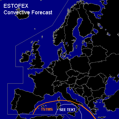

CONVECTIVE FORECAST
VALID 06Z THU 09/12 - 06Z FRI 10/12 2004
ISSUED: 08/12 18:16Z
FORECASTER: GATZEN
General thunderstorms are forecast across southern and central Mediterranean
SYNOPSIS
Well developed high present over central Europe ... and quite stable airmass will affect most of the continent. South of the blocking high ... a cut-off low moves slowly eastward across the northern Algerian/Tunisian boarder. East of this feature ... warm airmass originating from the Sahara is present.
DISCUSSION
...Southern and central Mediterranean
...
Focus of convective activity will be the cut-off low over southern Mediterranean. Along the southern edge of this feature, a jet streak travels eastward just south of the forecast area ... while winds will be weak over southern Mediterranean. East of the upper trough ... an airmass characterized by steep mid-level lapse rates is advected NE-ward into central Mediterranean ... and low-level moisture has recovered during the last days reaching a mixing ratio of 8 g/kg in the lowest kilometer as indicated by latest LICT Trapani ascent. This results in instability with CAPE in the order of several 100 J/kg. On Thursday ... CAA is expected over southern Mediterranean west of a poor developed frontal boundary ... while instable airmass is forecast to spread eastward. DCVA just north of the mentioned jet streak should lead to QG UVM to the north of the CAA regime ... and widespread showers and thunderstorms are expected to form from southern Italy and Sicily to Sardinia and Corsica. As deep vertical wind shear will be quite low ... severe thunderstorms seem to be not likely. However ... intense precipitation will be possible in the range of slow-moving thunderstorms. There is also a enhanced chance for waterspouts in the range of the upper trough axis .. where vertical wind shear should be very low. Thunderstorms may merge into a cluster spreading eastward during the forecast period.
#