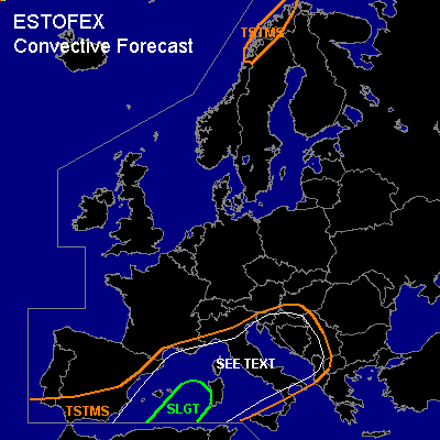

CONVECTIVE FORECAST
VALID 06Z FRI 03/12 - 06Z SAT 04/12 2004
ISSUED: 02/12 17:29Z
FORECASTER: GATZEN
There is a slight risk of severe thunderstorms forecast across southwestern Mediterranean
General thunderstorms are forecast across western and northern Mediterranean, western Balkans
General thunderstorms are forecast across northern Norway
SYNOPSIS
To the east of amplified upper long-wave trough extending from Scandinavia to Atlantic Ocean SW of Iberian Peninsula ... a strong upper jet is present over the western and northern Mediterranean, and eastern Europe. As this upper trough starts to cut off over Iberian Peninsula ... a weak upper ridge will expand from northeastern Atlantic to central Europe. At lower levels ... tongue of warm and unstable airmass over central Mediterranean will spread westward into western Mediterranean east of building cut off low.
DISCUSSION
...Western Mediterranean
...
As upper low starts to cut off over Iberian Peninsula ... DCVA is expected with this feature that should affect western Mediterranean on Friday ... and weak cyclogenesis is expected over southwestern Mediterranean indicated by latest GFS model output. As warm airmass over central Mediterranean spreads westward ... QG forcing should result over the affected region. Warm airmass is characterized by steep mid-level lapse rates and quite rich low-level moisture ... and GFS CAPE calculation seems to be reasonable as latest soundings show CAPE up to 700 J/kg locally. Showers and thunderstorms are expected to form over the western Mediterranean and should spread northward. Although deep vertical wind shear is forecast to decrease over western Mediterranean ... it is expected that organized convection will form underneath the cyclonic flank of the upper jet ... where deep vertical wind shear will exceed 20 m/s. Multicells and mesocyclones may form capable of producing isolated large hail, severe wind gusts and a tornado or two. Thunderstorms will likely merge into a MCS as QG forcing should persist during the night hours.
...Italy, Adriatic, western Balkans
...
Quite unstable airmass is present over central Mediterranean and should be advected northeastward into the Balkans. Underneath the right entry region of upper jet streak that is expected to move eastward over the southeastern Alpine region ... synoptic forcing will be likely. Although instability should be limited ... and low-level CIN may be quite high ... forcing may be locally strong enough to initiate thunderstorms over the western Balkans, Italy, and Adriatic. Rather strong deep layer wind shear will be sufficient for organized convection ... and isolated large hail and severe wind gusts are forecast. A tornado or two is not ruled out as low-level vertical wind shear will be relatively strong.
#