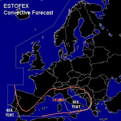

CONVECTIVE FORECAST
VALID 06Z WED 01/12 - 06Z THU 02/12 2004
ISSUED: 01/12 09:09Z
FORECASTER: GROENEMEIJER
General thunderstorms are forecast across the coastal regions of the Iberian peninsula, the western and central Mediterranean region and the wetsern Balkans.
SYNOPSIS
Wednesday at 06Z... a mid/upper low pressure system was located over southwestern Germany and is expected to move northeastward reaching southern Sweden on Thursday morning. On its southern flank a southwesterly flow of warm an approximately neutral air mass over the western and central Mediterranean. Another low is stationary over western Iberia. A jet off the Atlantic is rotating around the southern edge of the low and moving over southern Spaina nd the western Mediterranean.
DISCUSSION
...
Italy, Adriatic...
Low amounts of CAPE in the aformentioned air-mass will likely be released in a few thunderstorm clusters that move northeastward. Adequate deep-layer and rather strong low-level shear may aid the formation of a few mesocyclones. This implies that a few isolated severe events may occur.
...southern Portugal, western Andalucia...
Although instability is expected to be low here as well, forecast strong deep-layer shear creates some risk for of mesocyclones developing with thunderstorms, that are expected to increase in coverage. Some severe wind events and possibly a tornado and some marginally severe hail are possible. Overall threat, however, is too low to require a risk category.
#