CONVECTIVE FORECAST
VALID 06Z TUE 23/11 - 06Z WED 24/11 2004
ISSUED: 23/11 00:49Z
FORECASTER: VAN DER VELDE
General thunderstorms are forecast across the Ionean Sea and the coast of Greece
General thunderstorms are forecast across the Black Sea
SYNOPSIS
A depression with a strong pressure gradient is progressing southeastward from central Scandinavia. Behind the cold front, cold maritime polar air will expand over northern and central Europe and will have reached most of southeastern Europe by the end of the forecast period. Over southwestern Europe a blocking omega high is being established, while high pressure at the surface shifts from western to central Europe after the forecast period.
A weak tongue of relatively high theta-e and some low-level convergence is expected to produce slightly unstable conditions over the Ionean Sea with some thunderstorms.
Generally, unstable conditions are present at and behind the cold front, however the depth of instability will mostly limit organised thunderstorms.
DISCUSSION
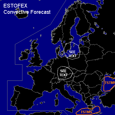
...southeastern Sweden and northern Poland...
Wintry showers can be expected, especially over Poland. Due to the expected strong pressure gradients, severe straightline winds are likely. These can be enhanced by convective activity and reach over 60 kts incidentally. Over northern Poland, ample low level shear (>15 m/s 0-1 km) is forecast and this may induce tornadoes if updrafts become strong enough to tilt vorticity.
...southern Germany, Austria, Czech Republic...
GFS 18Z and NMM 12Z models forecast some low level instability at the cold front passage. This could mean some lightning activity along with the strong forcing, however the depth of instability is forecast by NMM to be only 3 km. Since shear parameters (DLS/LLS/SREH) all look impressive, rotating updrafts capable of associated marginally severe weather (hail, gusts, isolated tornado) may occur ....provided that convection does organize deeply enough, e.g. into a shallow squall line.
#