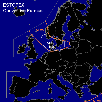

CONVECTIVE FORECAST
VALID 06Z THU 18/11 - 06Z FRI 19/11 2004
ISSUED: 17/11 17:35Z
FORECASTER: GATZEN
General thunderstorms are forecast across North Sea region Benelux and NWrn Germany, southern Scandinavia, southern Baltic Sea region
General thunderstorms are forecast across southern Greece
SYNOPSIS
A intense upper long-wave trough remains over northern Europe. At its southern flank ... a strong jet is present over the central parts of Europe. At lower levels ... a frontal boundary expands from northern Great Britain to Denmark and further to western Black Sea. Along this boundary, models suggest intense cyclogenesis during the forecast period over southern Scandinavia and Central Europe... while cold airmass will be advected southward into northern France, northern Germany, and northern Poland until Friday, 6Z. Over the Mediterranean ... stable airmass is present west of broad upper long-wave trough over southeastern Europe.
DISCUSSION
...North Sea and Baltic Sea region
...
On Thursday ... strong surface low pressure system is expected over western Baltic Sea. Associated cold front will move southwards over England, Benelux, Germany, and Poland. To the north ... cold airmass will destabilize over the North Sea and Baltic Sea. Although cold air advection is expected over the affected region ... several upper vort-maxima should lead to UVM ... and showers and thunderstorms are forecast that should reach Benelux and northern Germany during the forecast period. Very strong deep vertical wind shear will be more than adequate for organized convection. However ... expect low instability and rather low synoptic forcing as cold air advection will be present over most of the region ... strong thunderstorms will be unlikely. If convective cells will organize ... severe wind gusts will be the main threat. One or two tornadoes are not completely ruled out, though.
#