
CONVECTIVE FORECAST
VALID 06Z TUE 16/11 - 06Z WED 17/11 2004
ISSUED: 16/11 01:02Z
FORECASTER: VAN DER VELDE
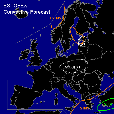
There is a slight risk of severe thunderstorms forecast across Southern Turkey
General thunderstorms are forecast across the Ionian Sea, Greece and the Aegean Sea, the western Norwegian coast, and the Botnic Gulf into the northen Baltic States
SYNOPSIS
Between a high pressure area over the Atlantic/western Europe, and a strong low pressure area over Scandinavia, a northwesterly flow dominates much of Europe. Unstable conditions exist primarily over large water surfaces in Scandinavia and the Baltic States, and near the surface low/eastern flank of the upper trough around Greece and Turkey.
DISCUSSION
...SLGT risk area...
GFS 12Z/18Z forecasts several hundred J/kg CAPE and moderate to strong deep layer shear values over western/southern Turkey. Given also the previous day 12Z sounding of especially Heraklion, Crete, very strong shear appears to be present in some places in addition to strong buoyancy and the situation will not change that much over the forecast period. Strong synoptic scale forcing is forecast by GFS. Storms are expected to cluster or organise into an MCS and some updrafts may develop rotation. With these storms, large hail is a possibility and marginally severe gusts. A tornado is not ruled out, but 0-1 km shear and SREH values, and LFC heights are not particularly high, respectively low. Most convective activity and rainfall is expected near the south and west coast.
West of the SLGT area, waterspouts are expected especially given yesterdays 12Z sounding of Trapani/Sicily showing strong low level buoyancy and humidities, along with weak shear in the lower levels. This sounding is thought to be representative for the airmass over the Ionean Sea.
...Estonia, Latvia...
As cold unstable air flows over the relatively warm Botnic Gulf, snow/graupel showers will develop (-20C at 3 km). Given the strong pressure gradient, these showers can produce strong gusts and accumulation of snow. This combination may be hazardous for traffic.
...Central Europe...
GFS forecasts low-level buoyancy at an occlusion that enters the area from the north. Although the convection that may result of this may not be deep and produce thunder, strong low-level shear and low LFCs might cause briefly rotating updrafts that support a tornado - if low-level buoyancy is indeed correctly forecast by the model.
#