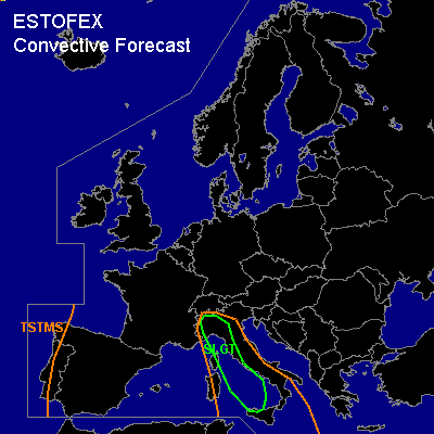

CONVECTIVE FORECAST
VALID 06Z TUE 02/11 - 06Z WED 03/11 2004
ISSUED: 02/11 00:44Z
FORECASTER: VAN DER VELDE
There is a slight risk of severe thunderstorms forecast across northwestern Italy and the central Mediterranean Sea, including western Italy, Corsica and Sicily
General thunderstorms are forecast across the extreme western Iberian Peninsula
SYNOPSIS
A blocking MSL high pressure area with its core near southern Scandinavia dominates much of northern Europe. An old upper low has moved from the Gulf of Biscay into the western Mediterranean, and will disappear, while a shallow MSL low lingers around. At its east side, warm and moist air is transported rapidly northward and instability has been created along a sharply bounded tongue of high theta-e (cold front).
Low pressure and a tongue of high theta-e is also approaching the Iberian Peninsula from the Atlantic.
DISCUSSION
...SLGT area...
The previous day has seen convective storms developing along the cold front. GFS forecasts the low to take a southerly course, which would tilt the theta-e gradient back from Corsica to Sicily, barely touching the west coast of Italy. GFS and NMM hint at 1000-2000 J/kg in the center of the theta-e tongue, with a few hundred J/kg available in northwestern Italy. This is not unlikely given the 12Z Pratica di Mare sounding of the previous day, which had a capped 1500 J/kg. LFCs will be high/large cap/weak lift over most of Italy and the Adriatic, likely enough to prevent development of convective storms.
Ascending motions are prognosed to be strongest in the WAA region at the nose of the theta-e zone, over northwestern Italy. Together with the upslope winds, this setup is able to produce large amounts of precipitation at the south side of the Alps, as many models agree - more than 20mm in 3h is forecast by NMM in some locations for most of the day.
The cold front is overspread by strong upper winds. Vertical shear values over the instability axis are expected by the GFS and NMM models to be moderate, near the cold front where forcing and LFCs are best the various shear parameters will be rather strong, with also wind profiles veering with altitude (0-3 km SREHs 100-300 m2/s2 in GFS 18Z, >100 by NMM22 12Z with >250 m2/s2 over northern Italy).
Conditions seem favorable for clustered storms, some of which supercellular and capable of producing large hail and possibly a tornado or waterspout and/or strong gusts. A linear MCS may develop along the cold front with a primary risk of severe gusts. (part of) the area may be upgraded to MDT risk if soundings show large low level buoycancies coupled with strong kinematics.
#