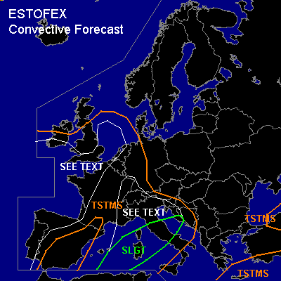

CONVECTIVE FORECAST
VALID 09Z FRI 29/10 - 06Z SAT 30/10 2004
ISSUED: 29/10 08:44Z
FORECASTER: GATZEN
There is a slight risk of severe thunderstorms forecast across central and northern Mediterranean
General thunderstorms are forecast across western Central Europe, western Alpine region, western Mediterranean, northeastern Mediterranean, southern Black Sea region
General thunderstorms are forecast across western Europe
SYNOPSIS
Intense upper long-wave trough placed over western Europe. Along its periphery, a strong upper jet affects a region from southern Iberian Peninsula to western Mediterranean ... and travels northeastward into Alpine region and eastern Central Europe later in the day. Several vort-maxima will rotate around the center of the main trough and should lead to QG forcing. At lower levels ... a frontal boundary expands underneath the upper jet ... deviding warm airmass over the Mediterranean that is locally unstable from colder maritime airmass originating of the Atlantic that is convetively mixed.
DISCUSSION
...Central and northern Mediterranean
...
Latest model output suggests that instability will form over central Mediterranean during Friday. Latest soundings show relatively steep mid-level lapse over the southern Mediterranean that should be advected northward. Over eastern Italy ... latest LIRE sounding shows rich low-level moisture ... and it seems that GFS CAPE assumption is plausible ... especially in the range of a frontal boundary that will reach Italy on late Friday. As upper jet streak/vort-max travels NEward over the western and northern Mediterranean ... a weak developed surface low will move eastward into northern Italy. Low-level convergence along the frontal boundary ... and QG forcing due to WAA and DCVA should be sufficient for thunderstorms. In the range of the upper jet streak ... strong deep vertical wind shear will be present ... and organized convection is expected. Multicells and mesocyclones are forecast capable of producing isolated severe wind gusts, large hail and probably a tornado or two. Convection should merge into one or two MCS moving NEward into northern Mediterranean ... where storms will likely be elevated as boundary layer is quite stable. Intense rain should be the main severe threat then.
...Western Mediterranean to SWrn Germany
...
Maritime airmass over western Alpine region is very moist and has almost neutral lapse rates as indicated by LFLL sounding. This airmass is expected to spread northward into western France, SWrn Germany, and Benelux. As upper vort-max approaches ... and diurnal heating sets in ... instability and QG forcing should allow for showers and thunderstorms. Over the western Alpine region, SWrn France, and SWrn Germany ... increasing deep layer vertical wind shear is expected in the range of the upper jet streak ... and organized convection may develop. Isolated large hail, severe wind gusts and a tornado or two are not ruled out. However ... overall threat seems to be too low to warrant a SLGT ATTM.
...Western Europe
...
Slightly unstable maritime airmass should allow for showers and thunderstorms over western Europe. Although deep vertical wind shear will be low ... locally rather strong low-level vertical wind shear will be present ... and it is not ruled out that shallow mesocyclones could form ... capable of producing a tornado or two.
#