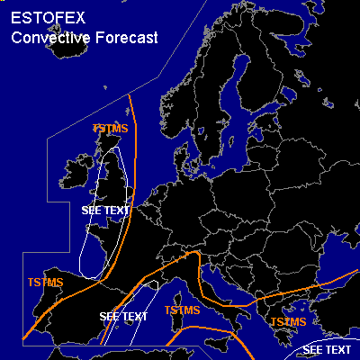

CONVECTIVE FORECAST
VALID 06Z THU 28/10 - 06Z FRI 29/10 2004
ISSUED: 27/10 18:32Z
FORECASTER: GATZEN
General thunderstorms are forecast across Turkey, Greece and eastern Mediterranean
General thunderstorms are forecast across Italy, southern France and western Mediterranean
General thunderstorms are forecast across western Europe
SYNOPSIS
Intense upper long-wave trough placed over western and northwestern Europe, yielding a deep southwesterly flow from northwestern Africa to Alpine region and further to Baltic Sea region, while upper ridge is present over southeastern Europe. A cut-off low propagates eastward over eastern Mediterranean. At lower levels ... relatively cold maritime airmass will spread southeastward in the range of eastern Atlantic storm system, while warm subtropical airmass is advected into western Mediterranean east of propagating cold front. Warm and unstable airmass will be present over eastern Mediterranean east of propagating cold front.
DISCUSSION
...Eastern Mediterranean
...
Warm and unstable airmass is present over the central and eastern Mediterranean ... characterized by relatively steep mid-level lapse rates and rather rich boundary-layer moisture ... yielding CAPE values in the order of several 100 J/kg as indicated by latest ascends. On Thursday ... low level CAA should be present west of a dissolving cold front that moves southeastward into eastern Mediterranean ... However ... backing low-level winds are forecast and instability is expected to remain. At the western flank of propagating upper cut-off low ... DAVA should be present over the region ... and QG forcing should weaken on Thursday ... and chances for showers and thunderstorms should decrease during the day. Weakening vertical wind shear in the wake of the cut-off low ... will limit severe potential. Best chances for isolated supercells should exist in the range and SE of Crete ... where instability and vertical wind shear will be strongest. Relatively low LCL height may support a tornado or two during the first half of the day. Isolated large hail and strong wind gusts are not ruled out.
...NWrn Mediterranean
...
Warm and slightly unstable maritime airmass is advected into western and NWrn Mediterranean east of propagating cold front ... while rather steep lapse rates originating from the Sahara desert are advected northward over central Mediterranean ... creating quite strong instability over the central Mediterranean on late Thursday. As upper long-wave trough over western Europe propagates eastward ... QG forcing should increase over the western Mediterranean due to vort-maxima that are embedded in the southwesterly current and relatively strong WAA. Along the frontal boundary ... showers and thunderstorms are expected that should move northeastward into southern France, northern Italy and southern Alpine region. Although vertical wind shear should remain relatively weak ... convection should merge into one or two MCS due to QG forcing as indicated by latest model output. Intense precip and local flash floods should be the main threat. However ... isolated mesocyclones are not completely ruled out ... capable of producing a tornado or two due to low LCL heights as well as isolated large hail/strong wind gusts.
...Western Europe
...
Occluded storm system is expected SW of Ireland on Thursday ... and well mixed maritime airmass is expected to the south and east of its center. As upper long-wave trough slowly propagates eastward over SWrn Europe ... a jet streak/upper vort-max is expected to rotate around the main trough reaching Great Britain during the day. In the range of this upper vort-max ... QG forcing should be sufficient to initiate showers and thunderstorms over western France, Bay of Biscay, and Great Britain. Strong vertical wind shear and rather high low-level SRH values are expected ... and multicells and mesocyclones are forecast ... capable of producing (isolated large) hail and severe wind gusts. If mesocyclones will form ... potential for tornadoes is enhanced due to low LCL heights and high low-level wind shear. Best potential for tornadoes is expected over England, where a few reports are expected. However ... instability will be quite low over England as indicated by latest GFS model run ... and overall threat seems to be too low to warrant a SLGT ATTM.
#