
CONVECTIVE FORECAST
VALID 06Z WED 27/10 - 06Z THU 28/10 2004
ISSUED: 26/10 22:57Z
FORECASTER: GROENEMEIJER
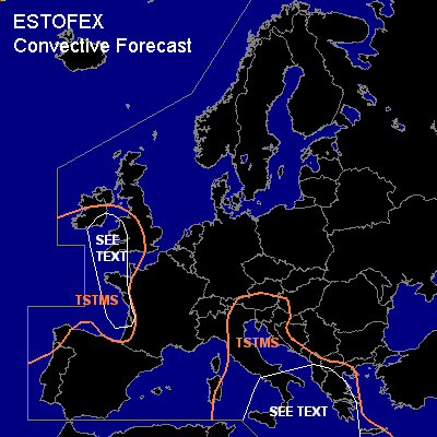
General thunderstorms are forecast across the southeastern Alps, central and southern Italy and the western Balkans and Greece as well as across southeastern Ireland and southwestern Britain, western France and northwestern Spain.
SYNOPSIS
Wednesday at 06Z... the most eye-catching system is a deep low pressure system approximately 500 km NNW of Galicia that moves slowly northward. The system is colocated with a low at mid levels with a strong cyclonically curved flow on its southern and eastern flanks. Over the northern half of Europe a modetly strong westerly flow is present. Over southern Europe, the flow is generally weaker. A north-south oriented trough trough over Corsica and Sardinia is expected to move eastsoutheastward during the period and reach the central Ionean Sea on Thursday morning.
DISCUSSION
...southeastern Ireland, southwestern Britain and western France...
Near and behind a cold front that reaches the French west coast during the late afternoon and England and southern Ireland in the evening hours, a couple of thunderstorms are likely.
Given that low-level and deep-layer shear will be strong, some storms may develop mesocyclones. These will be capable of producing marginally large hail, strong gusts and perhaps a tornado. Any mesocyclonic storms will probably be very isolated, so that a risk category is not needed.
...southern Italy, central Mediterrean, Albania, western and central Greece...
A number of MCS's is expected to continue their eastward movement during the forecast period.
MLCAPE available to these storms is expected to be in the 1000-2000 J/kg range.
Given that the wind shear is expected to be low the severe threat of the storms will be relatively low. Isolated gusty winds and large hail event cannot be ruled out.
#