CONVECTIVE FORECAST
VALID 06Z TUE 26/10 - 06Z WED 27/10 2004
ISSUED: 25/10 23:28Z
FORECASTER: VAN DER VELDE
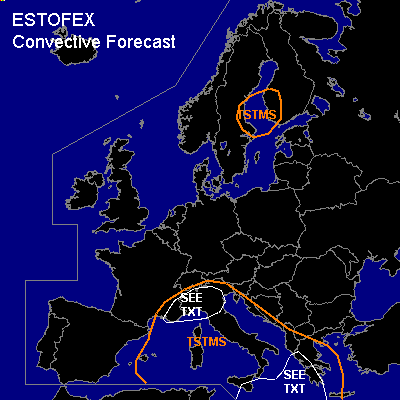
General thunderstorms are forecast across the central Mediterranean Sea, Italy, SErn France, Adriatic Sea, Albania and Greece
General thunderstorms are forecast across central Sweden, Baltic Sea, western Finland and Botnic Gulf
SYNOPSIS
A southwesterly upper flow regime is present over much of Europe. A low pressure area is developing as a wave in the frontal zone over southern France, where warm air advection and vorticity advection aloft from the approaching 500 hPa trough cause strong upward motion supporting cyclogenesis. The forcing along the advancing cold front is expected to be strong enough to overcome the cap over much of the central Mediterranean where soundings indicate deep elevated mixed layers with steep lapse rates.
By the end of the forecast period, a large depression having strong pressure gradients approaches the European Atlantic coasts with stormy conditions, dominating the weather in western Europe for several days.
DISCUSSION
...southeastern France, northern Italy...
The frontal zone is forecast to sharpen over this area and form a wave. Strong BL convergence and upslope winds along with strong synoptic scale ascending motions will lead to a major precipitation event. There is likely a convective aspect to this event as well. GFS 12Z forecasts a few hundred J/kg CAPE in the area at the nose of a high theta-e ridge and lower LFCs than more to the south, where elevated convection seems. NMM 12Z, however, is more conservative and really marginal looking. If surface-based convection becomes the major mode as opposed to larger scale precipitation and elevated convection, a slight risk will be present because the area will be in a strong shear regime, with more than 200 m²/s² SREH, more than 25 m/s deep layer shear (0-6km) and more than 10 m/s 0-1 km shear. This opens up a possibility for rotating updrafts and thereby a few tornadoes.
...coastal zones of Greece, Albania, Crete and Sicily...
A shallow barotropic low pressure area lingers around and steep lapse rates were present in yesterday's 12Z soundings. GFS 12Z predicts strong low-level buoyancy values in a low shear environment which seem favorable for waterspouts and weak tornadoes.
#