CONVECTIVE FORECAST
VALID 06Z MON 25/10 - 06Z TUE 26/10 2004
ISSUED: 24/10 23:29Z
FORECASTER: GROENEMEIJER
General thunderstorms are forecast across Iberia, southeastern France, southern Germany, the Alps, parts of Italy the western Balkans, Greece and the Turkish Meditarranean coast as well as much of the North Sea, northern England and southern Scotland and parts of southwestern Scandinavia.
SYNOPSIS
Monday at 06 Z... a longwave ridge is positioned along an axis from Sweden to the central Balkans. Upstream, a rather strong southwesterly flow at mid- and upper levels over much of western Europe. A shortwave is located over the southern North Sea. It stretches southward from a low pressure area at the surface. At the same time, a cold front is forecast to stretch from northern Germany southwestward over eastern France to central Spain. As another shortwave trough, that initially located west of Iberia affects the frontal zone during the forecast period, a baroclinic wave is expected form and move northeastward inducing cyclogenesis over the northwestern Mediterrnean.
DISCUSSION
...southeastern France and northeastern Spain...
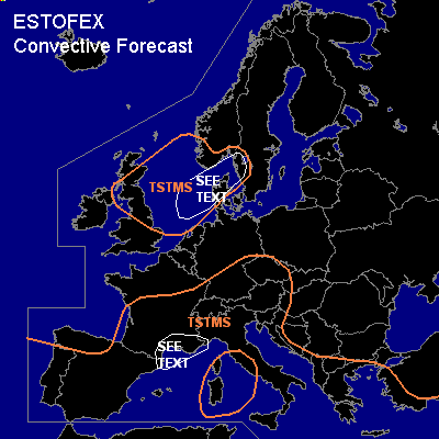
Along the front and ahead of it, some latent instability is forecast to form and be released by means of clustered thunderstorms. These will likely affect Catalonia, southeastern France during the evening hours. Storms are expected as well over the western Alps, including much of Switzerland and southern Germany. Low instability limits the severe threat, but an isolated severe wind, hail or tornadic event cannot be ruled out along the Mediterrean coasts of southeastern France and Catalonia as (low-level) wind shear is expected to be quite strong.
...Denmark, Sweden...
A small chance of isolated tornadoes and a larger chance of strong gusts, partially produced by convective storms are expected over parts of the southern North Sea, northern and central Denmark and southwestern Sweden as low-level shear and slight instability are expected to coexist over these areas.
#